Updated 21 Oct 2012
|
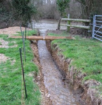
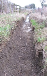
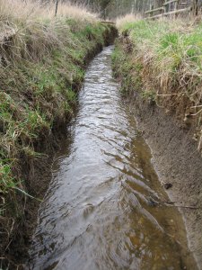
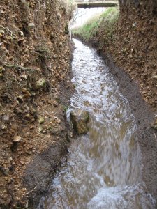
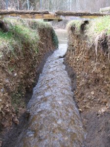
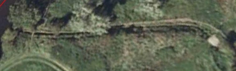
Tidal Trench
|
|
Tidal Trench on the Old Mill Stream
|
Looking South to Mill
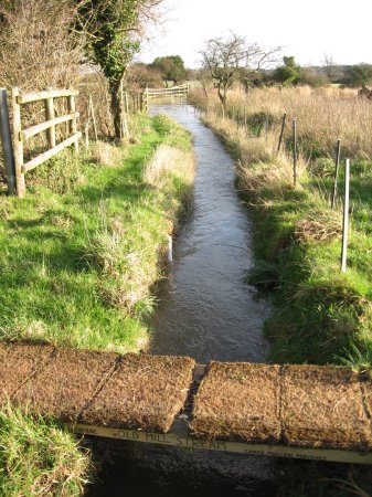 |
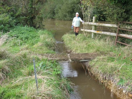
In Sep 2007, damage caused by blockage of an old arm of the River Stour
was repaired at Bear Mead near Wimborne in Dorset.
A trench was restored, reconnecting the river with the Old Mill Stream
by excavating and deepening 68 metres of the former channel.
The object was to re-introduce flowing water into an old,
2 mile long Mill Stream which had become heavily silted up.
Also to help store water in the Mill Stream during river flood and
drain it back afterwards.
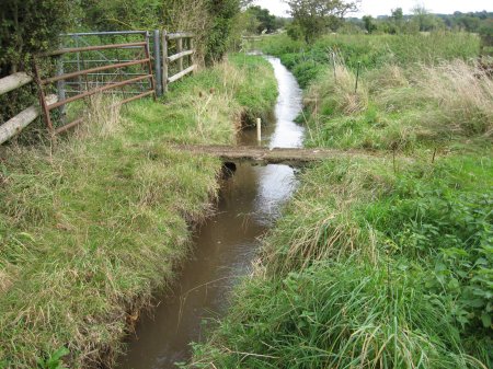
A strong flow has been observed through the trench both Northward
and Southward, hence the description "tidal".
The battle between instant local rain and delayed distant rain is
fascinating.
After observing three seasonal cycles of flood and drought, and lowering the
trench bottom in stages to 1 metre below surrounding flood level,
the results appear encouraging.
The trench is now visited by otters.
|
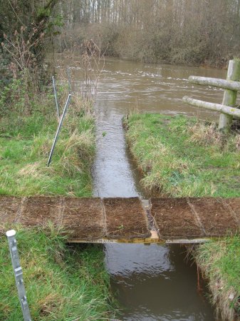
Looking North to river
 |
FLOW: |
South into Mill Stream |
North into River |
................ |
LEVEL: |
of River |
100m up Mill Stream |
................ |
RAINFALL: |
per Day |
River rising and filling the Mill stream reservoir.
FILL flow, 16 Jan 2008, 0841 hrs, R=356, MS=325.
 |
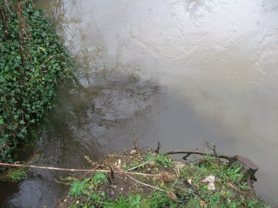
Meeting of the waters. The silt-laden Stour meets the much clearer
Mill Stream. Near balance, with slight flow into the Stour.
BALANCE flow, 29 Nov 2009, 1150 hrs, R=292, MS=293.
 |
River falling and Mill stream reservoir draining back into it.
DRAIN flow, 18 Jan 2008, 1549 hrs, R=267, MS=308.
 |
|
From Post 01, otter stone, river.
 |
From Post 01, otter stone, bridge.
 |
From Post 04, scale.
 |
From Post 11.
 |
From Post 17.
 |
|
Drain flow in trench, river=225,
 |
Mill Stream=275, 1630 hrs,
 |
27 Feb 2010
 |
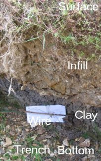
2813 Inclosure-type wire c1815
 |
|
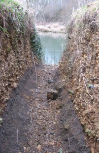
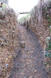
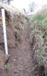
The Tidal Trench is 68 metres long, 1 meter wide and 1 meter deep.
It connects the River Stour with the Old Mill Stream. The Mill Stream is
an old arm of the Stour, now silting up but acting as a reservoir
around 3 kms long, 10 metres wide and 50 cms deep, holding around
15,000 cubic metres.
The trench bottom has a high point or hump 250 cms above datum
(as of Aug 09).
This prevents flow in either direction except under the following
circumstances:
- The River >250 and >the Mill Stream, producing
FILL flow.
- The Mill Stream >250 and >the River, producing
DRAIN flow.
- The rate of flow is proportional to the difference in levels.
- When flow occurs but levels are equal, an interesting oscillation
occurs along the trench, triggered by small level changes in the fast-flowing
river.
|
Flow will usually occur during the winter, when river and Mill Stream levels
are often high enough. However 5 July 2007 would have produced a good
FILL flow, due to country-wide rainfall that flooded much of middle
England.
FILL flow has the advantage of speeding storage of river water in the Mill
Stream reservoir when the river approaches flooding.
DRAIN flow assists drainage from the Mill Stream reservoir when flooding
is over.
The Mill Stream is unusual in that there are four inflowing brooks for
rainwater collected in nearby hills, and two outflow points which only work
for levels above 300. As a result the Mill Stream was usually stagnant. The
tidal trench now allows heavy rainfall to find its way to the river at a
level of 250, as is evident from clear water flowing into the silted river
at the North end of the trench.
After 1277 days of testing, the tidal trench was found to have:
 To May 2011
No flow: 73%
DRAIN:   23%
FILL:     4%
|
|
      Days with flow in trench
      DRAIN FILL        DRAIN FILL
-----Note 1-----
Dec 07  4    1    Dec 09  22   9
Jan 08  8    4    Jan 10  27   4
Feb     4    0    Feb     19   3
Mar     4    0    Mar     24   1
Apr     0    0    Apr      9   1
May     0    3    May      5   0
Jun     0    0    Jun      0   0
Jul     0    0    Jul      0   0
----Note 2------
Aug     0    0    Aug      1   0
Sep     1    0    Sep      0   0
Oct     3    0    Oct      1   0
Nov     9    3    Nov     12   0
Dec 08  9    2    Dec 10  10   0
Jan 09 11    2    Jan 11  20   3
Feb    14    2    Feb     18   0
Mar     6    0    Mar     26   0
Apr     2    0    Apr      2   0
May     0    0    May      0   0
Jun     4    0    Jun     na  na
----Note 3------  ----Note 4------
Jul     1    0    Jul     na  na
Aug     5    0    Aug     na  na
Sep     0    0    Sep     na  na
Oct     2    0    Oct     na  na
Nov    13    8    Nov     na  na
                  TOTAL  296  46
                  Ratio  6.4
Notes
1 Hump set at 300
2 Hump lowered to 270
3 Hump lowered to 250
4 Hump lowered to  ?
|
OTTERS in the Trench
The trench has now become a highway for wildlife.
From its excavation, otter footprints and spraint
were seen.
7 Jan 2010, Jane Adams
(Co-ordinator of
Nature Watch Corfe Mullen) placed a large stone at the bottom
of the trench, about 3 metres from the river.
9 Feb 2010, two large otter spraints were seen balanced
on top of the stone. Otters were using the stone as
a territory marker.
5 Mar 2010 a multitude of prints appeared
on the silt delta where the trench meets the river.
|
|
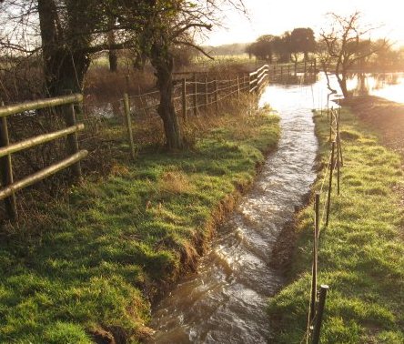
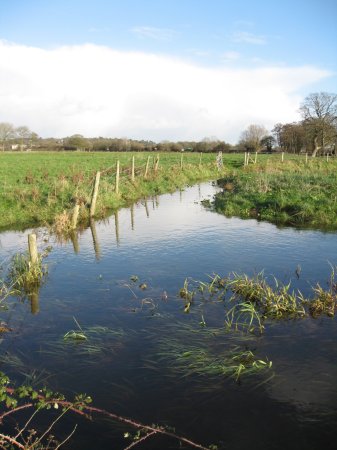
30 Nov 2009 Stour flows into the Old Mill Stream
Looking North, R=350, depth=1 metre.
|
1 Dec 2009 Flow continues down the Old Mill Stream
Looking South, R=343, depth=93 cm.
|
3 Dec 2009 Flow leaving Old Mill Stream into
Julian's Stream.Looking East, R=306.
 |
7 Oct 2012 Stour flows into Mill Stream.
Looking North, R=333.
 |
7 Oct 2012 Flow continues down Mill Stream.
Looking South, R=333.
 |
|
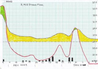
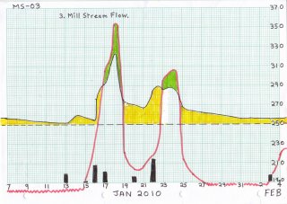
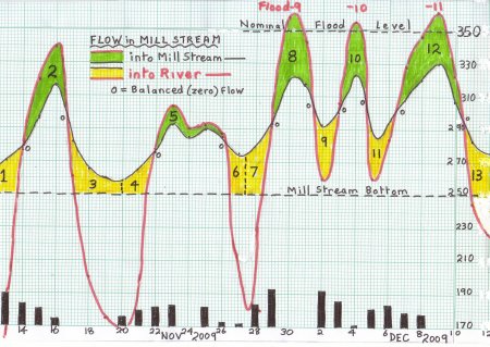
Two-directional "tidal" flow in the Old Mill Stream.
Flow reversed 10 times due to 241 mms rain in 31 days,
causing 3 floods.
|
Flow in the old Mill Stream
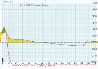
Work in summer 2009 took the level of the trench bottom down to 250,
ready for the wet season. River or Mill Stream levels above
250 produce two-directional "tidal" flows shown in the graph.
|
1,4,7 Other streams (OS) taking local rain into
the Mill Stream (MS) cause a rise in level even when there is a flow into
the river.
2. Inflow from the river and OS pulls the
MS upwards.
3,6 Zero local rain and drop of river causes
the exponential decay of MS.
5. River and MS levels nearly balanced, with
little flow either way.
8,10. Flow into the MS only from the river pulls the
MS up. Flow out via Julians stream (JS) prevents MS from rising above
about 320.
9,11 Heavy rain reverses fall of river and starts
filling MS via OS.
12 Continued heavy rain pushes river into flood.
Heavy inflow into MS pushes it up to 330. Dry period allows river to drop
and MS to drain into it.
13 River drops further, JS cuts off at 288, MSE at
about 280 and MS at 250.
|
Comparison of areas leads to the conclusion that inflow from river and
other streams are approximately equal.
|
Julian's stream (JS), 1 km long, leaves MS at SY997994, flows under
Julian's Rd, to SZ007992 near Merley Hall farm where it joins the
Stour. About 80% of water in full MS flows down JS into Stour, preventing
MS from rising above about 320.
See photos 62f, 62k, 62m, 62j.
|
|
|
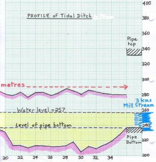
Lengthwise profile along 68 metres of ditch.
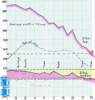 |
Pipe bottom defines lowest effective level.
 |
| |
|
Post  bot top wdth
01    253 398  95
02    255 392  90
03    254 393 100
04    254 388 120
05    253 383 130
06    252 387 120
07    249 379 105
08    247 372 125
09    251 366 115
10    246 353  95
11    253 355 100
12    248 345 105
13    243 348 100
14    244 329 100
15    250 340 110
16    242 317 100
17    240 305 115
|
Post  bot top wdth
18    237 302 115
19    238 288 110
20    231 281 120
21    214 279 130
22    213 283 125
23    210 277 125
24    213 283 115
25    213 283 110
26    212 279 110
27    212 282 115
28    213 287 115
29    218 285 115
30    205 280 115
31    212 286 120
32    209 284 105
33    214 282  95
34    219 280 105
|
Post  bot top
CBrN  227
Cpipe 237 332
CBrS  238
MS
|
|
MILL STREAM FLOW: |
S(outh) into Mill Stream |
N(orth) into River Stour |
**=Balanced (zero) flow |
01   NOVEMBER  2009
     196 mm (350cm) (250cm)
Date   Rain  River  MillStream
 1      21    -      -
 2       0    -      -
 3       4   173    256
 4       1    -      -
 5       0   210    253N
 6       5    -      -
 7       0   160    250
 8       0    -      -
 9       0    -      -
10       6   145    248
11       2   147    250
12      13    -      -
13      20   163    270N
14      13   277    278**
15      11   329    296S
16       5   333    315S
17       0   255    282N
18       0   200    265N
19       0   175    260N
20       6   167    258N
21      10    -      -
22      12   277    275N
23      13   303    292S
24       0   290    285**
25      12   292    289**
26       3   289    285**
27       2   212    275N
28      14   180     -
29      23   292    293N
30       0   357    320S
|
       DECEMBER 2009
     150 mm (350cm) (250cm)
Date   Rain  River  MillStream
 1       0   343    318S
 2      22   260    293N
 3      16   306    300S
 4       1   354    323S
 5      11   260    290N
 6      14   284    294N
 7       8   328    308S
 8       6   347    320S
 9       6   361    330S
10       0   322    307S
11       0   245    283N
12       0   227    276N
13       0   217    271N
14       0   210    267N
15       2   206    267N
16       2   206    266N
17       1   208    266N
18       0    -      -
19       0   196    262N
20       2   192    262N
21       2    -      -
22       4    -      -
23       9    -      -
24      15    -      -
25       0   222    272N
26       5    -      -
27       2    -      -
28       0   205    271N
29      11    -      -
30      11   275    281N
31       0   292    288N
|
78     JANUARY 2010
      72 mm (350cm) (250cm)
Date   Rain  River  MillStream
 1       0    -      -
 2       0    -      -
 3       0    -      -
 4       0   182    261N
 5       1    -      -
 6       2   175    258N
 7       0   174    256N
 8       0   170    256N
 9       0    -      -
10       0    -      -
11       0   165    253N
12       0    -      -
13       9    -      -
14       0   179    259N
15       1    -      -
16      18   231    276N
17      11   305    291S
18       0   353    322S
19       0   221    276N
20       6   203    270N
21       0   207    266N
22      24    -      -
23       0   295    286S
24       0   306     -
25       0   214    268N
26       0   198    264N
27       0   190    262N
28       0   187    261N
29       0    -      -
30       0    -      -
31       0   184    256N
|
79     FEBRUARY 2010
     89 mms (350cm) (250cm)
Date   Rain  River  MillStream
 1       0   181    256N
 2       0    -      -
 3       7    -      -
 4       1   218    256N
 5       4   215    257N
 6       4   220    259N
 7       0   204    256N
 8       0    -      -
 9       0   184    255N
10       0    -      -
11       0   175    252
12       0   170    251
13       0   168    251
14       0   166    251
15       0   165    250
16       4    -      -
17       4   177    253
18       9   183    257N
19       0   280    265S
20       0   242    263N
21       5   197    257N
22      11   261    265N
23       7   290    280S
24       6    -      -
25       6   232     -
26       0   239    266N
27      11   225    275N
28      10   286    277N
|
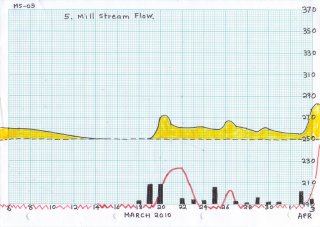
80     MARCH 2010
      80 mm (350cm) (250cm)
Date   Rain  River  MillStream
 1       0   291    282S
 2       0   216    267N
 3       0   186    263N
 4       0   186    261N
 5       0   180    260N
 6       0   175    260N
 7       0   173    260N
 8       0    -      -
 9       0    -      -
10       0    -      -
11       0    -      -
12       0   165    253N
13       0    -      -
14       0   163    250
15       0   155    250
16       0    -      -
17       0   160    250
18       3   160    250
19      18    -      -
20      18   196    270N
21       0   222    263N
22       5    -      -
23       4    -      -
24       3   185    262N
25      16    -      -
26       0   224    266N
27       2   192    262N
28       1   184    260N
29       6    -      -
30       2   186    260N
31       2    -      -
|
81     APRIL 2010
        mms (350cm) (250cm)
Date   Rain  River  MillStream
 1       0    -      -
 2      12    -      -
 3       5    -      -
 4      12   295    278S
 5       5   282    282N
 6       0   205    264N
 7       0    -      -
 8       0   181    260N
 9       0   175    259N
10       0   174    259N
11       0   172    257N
12       0   171    255N
13       0   172    253N
14       0    -      -
15       0   165    251
16       0   165    252
17       0   165    250
18       0   162    249
19       0   160    247
20       0   160    246
21       0   158    245
22       0   157    245
23       0    -      -
24       -    -      -
25       -    -      -
26       -    -      -
27       0    -      -
28       0   153    240
29       0   153    250
30       0   152    252N
|
5. EYE MEAD from a Map of Wimborne Parish 14 July 1847
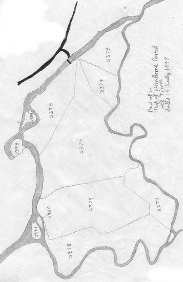
|
Points of Interest:
- The 2007 tidal trench now lies between island 2381
and the lower shore on this 1847 map
- Lake Mill Stream is about 1.75 miles in length, enclosing an area of
119 acres of meadow and pasture on the Stour floodplain.
- The numbers are reference numbers to fields awarded at the time of
the Inclosure Act 1813.
- 2380-2381-2383-2384 were islands in 1847, today they have "grafted"
onto the nearest bank, possibly part of the canalisation exercise on the River.
- These "old islands" still retain close-growing 200-year mature trees,
including white willows and alders, that have nearly vanished from the
mainland.
- The peninsula on field 2373 where the two Stours re-met, and the
oxbow, show the water in the minor loop once had a sturdy flow.
- The peninsula where the Mill Stream rejoins the Stour has today
silted up, but a direct channel now exists.
- Lake Mill was located near the little island and field 2377, at
OS reference 9955-9912 where there is now a low earth platform.
- A spur down to the river from Cowgrove Road existed then, as well
as a ford or possibly a bridge where the present wooden footbridge is.
- Rodney Legg says "Traditional agriculture used to encourage
the flooding [of these meadows] in winter as this prevented the ground
freezing and brought on an early crop of grass."
|
Old Mill Stream from Space |
2001 Cattle trampled areas.

|
2002 Cattle track over concrete bridge.

|
Sale
of
Land
Nov.
2002 |
2005 Cattle removed.

|
2007 Blocked Trench. Large undrained area.

|
Stream
unblocked
18 Sep 2007 |
2009 Restored Trench. Footbridge built.
|
Compiled, formatted, hyperlinked, encoded,
and copyright © 2008, John Palmer,
 All Rights Reserved. All Rights Reserved.
|
|