Updated 28 June 2014 |
Raasay East coast walk |
See Webmaster's other websites |
Raasay East coast walk |
24 May 1995 |
Forest-Seashore-Mountain-Moorland |
Rosie and I agreed that just about the best day's walk we had ever done was on the Isle of Raasay, Scotland in May 1995. About 8 miles, it took us 8 hours in good weather. The Youth Hostel warden called Satyam used our car to take us to the start, and we got back to the Hostel again, tired and dehydrated. Using our own map, photos and logbooks, and providing links to 40 really good photos by other people on Geograph, this webpage has brought back a lot of good memories.The key to the whole magnificent walk is: Be driven to the start; stay the night at the Hostel; and use a steep, narrow gully to get from seal level to the East side of Dun Caan. |
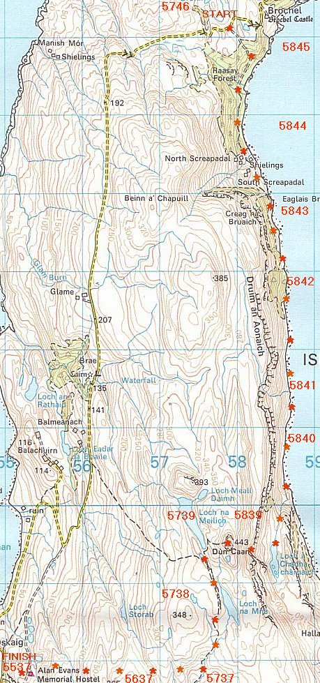
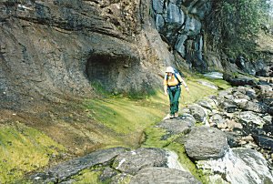
The magic wood
|
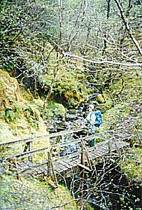
The big fat seal
|
Inverarish burn
|
Slippery stones
|
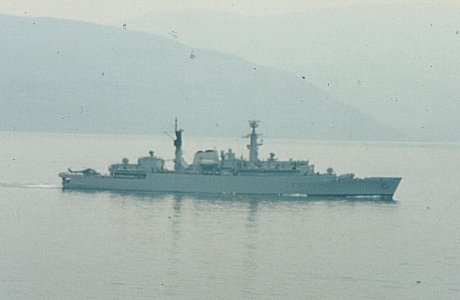
HMS Brazen, Type 22 frigate in the bay
|
The way up
|
A steep bit
|
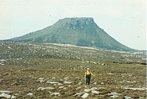
Top of Dun Caan
|
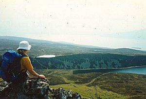
Home across the moor
|
 |
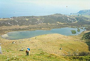
Wed 24 May 1995 From JOHN's logbookSlept well. Woke at 7. No rain, warm & milky outside. After breakfast, Satyam drove with us to near Brochel, the start of the East Coast walk. Satyam drove our car back for us. Mike came too, the thin climber we met at Glenbrittle. The walk first goes through a dense conifer forest, but where there is light and water, the greenery of moss & trees & lichen is magic. Then we left the conifers & followed a path half way up the green slope, black clifs of basalt towering above us, boulder strewn shore beneath. We saw a seal, then saw it dive & it had a tail (an otter?). But it had a seals head. In fact both seal & otter were there, diving for food in the quietly lapping water. Bluebells, primroses, even white flowers of shamrock. Its a magic place. Across the bay we saw a naval ship (frigate) with helicopter pad at stern & a helicopter. Nearby was a submarine, tall fin & conning tower a long way forward. Nuclear attack submarine? Trident sub? We went a bit wrong, walked too far along the shoreline, jumping between huge boulders of basalt, and there was a path 20ft above. The sea is like a millpond, its become very hot & humid & still. The frigate (F91) is going in circles & across the water (at least 1 mile) we can hear its loudspeaker. 4.15pm. On top of Dun Caan. Great views in all directions. There is a wide path up to Dun Caan from the West, but we had to climb to a Lochan & then steeply up to a gulley which is narrow, steep & a bit hairy. More slogging & we reached the trig point at the top. Hot, still & misty. The steep walls of the 2 lochans to our West are a surprise. The walk across the moors to the hostel was hard. Every ridge had a valley & another ridge beyond, we cossed maybe 10 ridges before, about 6.30, we reached the hostel, tired and dehydrated. The walk has taken about 8 hours, the weather lovely, but hot & humid.. Gave myself a good wash, first for days! Wed 24 May 1995 From ROSIE's logbook Up at 7.15am - Slept until about 6.45am - Went into ladies lavatory for obvious and washing bottie. Went back into dorm-cum-office to wash rest when as I was drying myself, in walked Satyam!! About 9am Mike, thin fellow in shorts from Glenbrittle YH, rolled up & at about 9.30 am Mike came with us & Satyam in car to near Brochel where a foot- path starts for E.Coast through Raasay forest. Satyam drove car back. Mike did "his own thing" and John & I walked along East Coast first through forest & then along a rough coastal footpath. We were briefly rained on & then gradually weather improved & it was very warm & sunny for the rest of the day! We had a laugh 'cos we saw a seal (commonseal?) & then John says "No, its an otter!". I sez, "Don't be daft, that's a seal!" "No, its an otter!", sez he. It turned out that there were 2 animals, 1 a seal & t'other an otter. Seal just submerges to fish & otter dives to fish & you see his tail as he goes under. Later we saw 2 seals basking on submerged rocks. They looked very uncomfortable! We saw plants that were of the Oxalus family?? Wood sorrel (white flowers with pink thin stripes). In the sea, between Raasay & Applecross were a naval frigate & a nuclear? submarine. Many bluebells along coast so there must have been deciduous trees at one time there. [Moss grows everywhere in the conifer forest either side of the footpath]. Dead sheep everywhere inc. 1 in process of dying. We went wrong here, we should have turned right and up over a cliff - instead we had to rock-hop which was not very pleasant as rocks were often slippery due to being washed by dripping water from above and were covered by green plant life. Eventually we got onto the footpath by climbing up the bank. We turned up a gully and above Loch a Chadha charnaich which was on our left. Turned right up steep grassy, rocky slope & then through a dodgy bit of a gully (loose bits of rock). Onto grass, heather & rocks again (Beware of 30ft drop on righthand side of top of gully!!) to summit Dun Caan. Down official path to Loch na Meilich, which is the island's water supply [Saw 2 or 3 (Black Guillimots) black "ducks" with white side patches, in sea]. Up path to small lochan where a party of children had gathered, some swimming! They were with 2 adults & were staying at the Outdoor Centre. Water was very cold in deeper bits! John & I then went by compass + 3 cairns across the vast undulating moorland back to hostel. This comprised of ridges (where the cairns were) and gullies all the way back to hostel. We were exhausted by time we got back about 6.45pm! [On Dun Caan & other high places I have seen leaves of a lupin-type plant]. Bed about midnight. |
5746==================================  Gate and track to Raasay forest
NG 579 460
Gate and track to Raasay forest
NG 579 460
5845==================================  Ruined longhouse on Raasay's east coast
NG 580 458
Ruined longhouse on Raasay's east coast
NG 580 458
5844==================================  South Screapadal, Raasay
NG 58 44
South Screapadal, Raasay
NG 58 44
5843==================================  Creag na Bruaich, Raasay
NG 58 43
Creag na Bruaich, Raasay
NG 58 43
5842==================================  The rocky east coast
NG 586 428
The rocky east coast
NG 586 428
 Jumble of rocks
NG 586 428
Jumble of rocks
NG 586 428
 East coast
NG 586 428
East coast
NG 586 428
5841==================================  Drium an Aonaich, Raasay
NG 58 41
Drium an Aonaich, Raasay
NG 58 41
 Bracken hell
NG 586 411
Bracken hell
NG 586 411
5840==================================  The way up, Raasay's east coast walk
NG 587 401
The way up, Raasay's east coast walk
NG 587 401
 Rough coast walk
NG 586 401
Rough coast walk
NG 586 401
5839==================================  Loch a' Chada-charnaich, Raasay
NG 58 39
Loch a' Chada-charnaich, Raasay
NG 58 39
 Loch ŕ Chadna charnaich
NG 584 393
Loch ŕ Chadna charnaich
NG 584 393
 The path to Dun Caan
NG 5758 3945
The path to Dun Caan
NG 5758 3945
5739==================================  Dun Caan
NG 578 394
Dun Caan
NG 578 394
 Summit view, Dun Caan
NG 5793 3948
Summit view, Dun Caan
NG 5793 3948
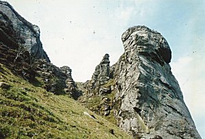
 Basalt cliffs, Dun Caan
NG 5792 3954
Basalt cliffs, Dun Caan
NG 5792 3954
 Rocky outcrops on Dun Caan
NG 5789 3947
Rocky outcrops on Dun Caan
NG 5789 3947
|
5739==================================  The ascent of Dun Caan
NG 5783 3953
The ascent of Dun Caan
NG 5783 3953
 Loch na Meilich
NG 5744 3975
Loch na Meilich
NG 5744 3975
 On top of Dun Caan
NG 579 395
On top of Dun Caan
NG 579 395
 Loch na Meilich
NG 575 394
Loch na Meilich
NG 575 394
 Dun Caan
NG 575 393
Dun Caan
NG 575 393
 Summit of Dun Caan
NG 579 395
Summit of Dun Caan
NG 579 395
 Dun Caan
NG 579 395
Dun Caan
NG 579 395
 Dun Caan
NG 578 395
Dun Caan
NG 578 395
 Dun Caan, Raasay
NG 57 39
Dun Caan, Raasay
NG 57 39
5738==================================  Loch na Mna
NG 578 386
Loch na Mna
NG 578 386
 Loch na Mna
NG 578 388
Loch na Mna
NG 578 388
 Loch Na Mna
NG 5791 3870
Loch Na Mna
NG 5791 3870
 Cairn on the Dun Caan path
NG 5771 3823
Cairn on the Dun Caan path
NG 5771 3823
 Cairn on the Dun Caan path
NG 577 383
Cairn on the Dun Caan path
NG 577 383
5737==================================  Glaciated exposures by the Inverarish Burn
NG 575 377
Glaciated exposures by the Inverarish Burn
NG 575 377
 Inverarish Falls, Raasay
NG 574 372
Inverarish Falls, Raasay
NG 574 372
 The Dun Caan path
NG 5748 3764
The Dun Caan path
NG 5748 3764
 A first view of Dun Caan
NG 5754 3797
A first view of Dun Caan
NG 5754 3797
 Path going down to Inverarish burn
NG 570 370
Path going down to Inverarish burn
NG 570 370
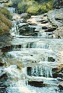
5637==================================  Waterfall in Raasay Forest
NG 566 370
Waterfall in Raasay Forest
NG 566 370
5537==================================  Raasay Youth Hostel
NG 553 378
Raasay Youth Hostel
NG 553 378
 Raasay Youth Hostel
NG 553 378
Raasay Youth Hostel
NG 553 378
|
Collected, written, formatted, hyperlinked, hand-coded,
and copyright © 2014,
|
 . All Rights Reserved.