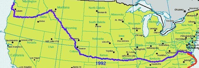
This file, in its original Amstrad Locoscript format,
was used to plan the route, 5 months before take-off.
Large gaps between motels, and high passes were the
main concern. Dates were estimated.
The numbers show where we actually stopped each day.
refer
|
Oregon |
Idaho |
Montana |
Wyoming |
Colorado
Kansas |
Missouri |
Illinois |
Kentucky |
Virginia
TransAmerica Bicycle Trail 24 Mar 92
=====START=====
SECTION 1 235 miles 4 Days
(M=Motel/Hotel nearby,
F=Friendly accomodation)
(Coast road flatish.
Heavy rain and fog possible in W.
Drier and cooler in E.)
|
12 AUG
-----OREGON-----
1 25 miles
M Astoria
Miles Crossing
M Seaside
- Cannon Beach Jct
2 30 miles
M Cannon Beach
Arch Cape
M Manzanita
M Nehalem
Mohler
3 38 miles
M Bay City
M Tillamook
M Oceanside
M Netarts
Sandlake
4 35 miles
Tierra del Mar
M Pacific City
Oretown
- M Neskowin
| Rose Lodge 400'
| 5 24 miles
| Boyer
52 Grand Ronde 500'
| Valley Junction
| Buell
| 6 12 miles
| Salt Creek
| Rickreall 500'
- M Salem
7 24 miles
M Monmouth 500'
Adair Village
Lewisburg
8 23 miles
M Corvallis 500'
Peoria
9 23 miles
Harrisburg
M Coburg
- M Eugene 500'
15 AUG
SECTION 2 345 miles 6 Days
Thunderstorms possible
W of McKenzie Pass.
High,dry,hot
low humidity plateau to E)
|
16 AUG
10 29 miles
Walterville 700'
Leaburg 650'
M Vida 700'
11 25 miles
M Nimrod 1,100'
Finn Rock 1,200'
Blue River 1,200'
- M McKenzie Bridge 1,750'
12 22 miles
**McKenzie Pass** 5,324'
13 27 miles
- M Sisters 3,300'
14 29 miles
M Redmond 2,900'
O'Neil 3,000'
15 26 miles
- M Prineville 3,000'
16 29 miles
**Ochoco Pass** 4,720'
- M Mitchell 2,800'
**Keyes Creek Sum** 4,357'
17 26 miles
18 25 miles
M Dayville 2,600'
19 24 miles
M Mount Vernon 2,900'
- M John Day 3,000'
M Prairie City 3,500'
| 20 30 miles
| **Dixie Summit** 5,277
36 Austin Jct 4,600'
| **Tipton Summit** 5,124'
| 21 34 miles 4,500'
M **Sumpter Summit** 5,082'
21 AUG
SECTION 3 400 miles 6 Days
Dry, hot, some steep climbs,
can reach 110°F in Hell's Canyon)
|
22 AUG
22 18 miles
- M Baker City 3,600'
**Flagstaff Hill** 3,684'
23 36 miles
M Richland 2,700'
** ** 3,600'
- M Halfway 2,800'
24 41 miles
M Pine Creek 2,200'
M Oxbow 1,900'
===Snake River=== 1,800'
** ** 4,200'
-----IDAHO-----
25 34 miles
M Cambridge 2,900'
- M Council 3,100'
26 27 miles
Tamarack 4,250'
M New Meadows 3,900'
27 21 miles
M Pinehurst 2,800'
Pollock 2,250'
28 25 miles
M Riggins 1,900'
Lucile 1,800'
29 25 miles
** ** 4,100'
- M Grangeville 3,300'
30 39 miles
Harpster 1,900'
Stites 1,300'
M Kooskia 1,300'
M Syringa 1,500'
31 33 miles
- M Lowell 1,700'
32 31 miles
- 3,200'
33 31 miles
M **Lolo Pass** 5,235'
-----MONTANA-----
Lolo Hot Springs 4,400
34 34 miles
M Lolo 3,400'
| 27 AUG
|
|
SECTION 4 330 miles 5 Days
(Eastbound Chinook wind.
Thunderstorms. Four well
graded passes)
|
| 28 AUG
| 35 26 miles
47 Florence 3,300'
| 36 27 miles
- M Stevensville 3,300'
Corvallis 3,500'
M Hamilton 3,600'
37 24 miles
M Darby 3,750'
Conner 4,000'
38 30 miles
- M Sula 4,500'
**Chief Joseph Pass** 7,242'
39 29 miles
M Wisdom 6,100'
40 28 miles
- M Jackson 6,300'
**Big Hole Pass** 7,360'
41 31 miles 5,900'
**Badger Pass** 6,760'
M Dillon 5,100'
42 24 miles
4,900'
43 28 miles
- M Twin Bridges 4,800'
M Sheridan 5,000'
Laurin 5,200'
Alder 5,600'
44 37 miles
Nevada City 5,800'
M Virginia City 6,100'
** ** 6,900'
M Ennis 5,000'
- M Cameron 5,200'
45 30 miles
M 6,100'
46 25 miles
- M W Yellowstone 6,700'
1 SEP
SECTION 5 350 miles 5 Days
(High plateaus with mountains.
Cool, semi-arid climate.
Winds from SE, often 40-60 mph)
|
2 SEP
-----WYOMING-----
47 34 miles
Madison 6,900'
M Old Faithful 7,300'
48 37 miles
**Craig Pass** 8,261'
**Cont Divide** 8,200'
West Thumb 7,900'
- M Grant Village 8,000'
49 28 miles
(G.Teton N.Park) 7,100'
M Colter Bay 6,900'
50 26 miles
- M Moran Jct 6,900'
M 51 30 miles
**Togwotee Pass** 9,658'
7,200'
52 24 miles
- M Dubois 6,900'
| 53 24 miles
| Burris 6,200'
72 Crowheart 6,000'
| 54 27 miles
| Ft.Washikie 5,400'
| 55 27 miles
- M Lander 5,300'
| 56 26 miles
58 ** ** 7,000'
| Sweetwater Station 6,400'
| 57 25 miles
- M Jeffrey City 6,200'
| 58 26 miles
| **Muddy Gap** 6,250'
| 59 23 miles
| ** ** 7,100'
- M Rawlins 6,800'
| 6 SEP
66
|
SECTION 6 365 miles 6 Days
(High altitude, average 8,000'
Cold nights, warm days, low
humidity)
|
42 7 SEP
| 60 17 miles
| Sinclair 6,600'
| 61 27 miles
| Walcott 6,600'
M Saratoga 6,900'
62 28 miles
- M Riverside 7,400'
| 63 27 miles 8,000'
| 7,700'
46
| -----COLORADO-----
| 64 27 miles
| Cowdrey 7,900'
- M Walden 8,100'
65 31 miles
**Muddy Pass** 8,772'
66 24 miles
- M Kremmling 7,500'
67 24 miles
M 8,800'
68 30 miles
M Silverthorne 8,900'
M Frisco 9,000'
- M Breckenridge 9,400'
**Hoosier Pass** 11,542'
69 28 miles
M Alma 10,300'
M Fairplay 10,000'
70 24 miles
M Hartsel 8,900'
- | **Currant Creek Pass** 9,404'
| 71 28 miles
56 6,100'
| 72 34 miles
M Canon City 5,800'
M Florence 5,800'
Wetmore 6,000'
73 21 miles
- M Pueblo 4,800'
12 SEP
SECTION 7 340 miles 4 Days
(Gradually downhill. Constant wind.
Dust storms possible.
Hot but very low humidity)
|
13 SEP
74 18 miles
4,600'
75 25 miles
Boone 4,400'
M Fowler
Olney Springs
76 23 miles
Crowley
- M Ordway 4,300'
| Sugar City
| 77 25 miles
62 Arlington
| Haswell 4,500'
| 78 23 miles
- M Eads 4,250'
79 23 miles
Chivington 4,000'
Brandon
80 21 miles
Sheridan Lake 4,000'
-----KANSAS-----
Towner
81 21 miles
M Tribune 3,600'
Whitelaw
82 22 miles
- M Leoti 3,250'
83 22 miles
M Scott City 3,000'
84 21 miles
Grigston
Amy
M Dighton 2,750'
85 23 miles
Beeler 2,500'
86 22 miles
- M Ness City
Bazine 2,250'
Alexander
87 22 miles
Nekoma
M Rush Center 2,000'
Timken
88 21 miles
- M Larned 2,000'
| 16 SEP
|
SECTION 8 300 miles 3 Days
(Downhill slowly. Dry in W,
humidity increases to E.
Winds from S or SW 10-12 mph)
|
| 17 SEP
| 89 25 miles
| Radium 2,000'
| Seward
65 90 26 miles
| Hudson 1,900'
| 91 25 miles
| Sterling
M Nickerson 1,600'
92 23 miles
Medora
Buhler 1,500'
93 30 miles
M Hesston
- M Newton 1,500'
| Elbing
| 94 21 miles
| Burns
| 95 32 miles
75 Cassoday 1,500'
| Rosalia
| 96 23 miles
- M Eureka 1,200'
| Neal
| 97 34 miles
60 Toronto 1,000'
| Coyville
| Benedict
| 98 26 miles
- M Chanute 1,000'
M Shaw
99 27 miles
Walnut
Girard 1,000'
19 SEP
SECTION 9 335 miles 6 Days
(Steep hills in E, "roller-coaster".
Climate very variable.
Wind from S and SE 7-9 mph)
|
20 SEP
100 26 miles
- M Pittsburg 1,000'
|
| ------MISSOURI-----
| 101 25 miles
| Golden City 1,000'
| 102 23 miles
| Pennsboro
113 Everton
| 103 30 miles
| Ash Grove
| Walnut Grove
| 104 23 miles
| Fairgrove 1,250'
- M Marshfield
| 105 25 miles
| Hartville
| 106 26 miles
61 Bendavis
| Fairview 1,250'
| 107 28 miles
| Bucyrus
- M Houston 1,250'
Yukon
Eunice
108 24 miles
Summersville
M Alley Spring
M Eminence 1,000'
109 31 miles
Owls Bend
- M Ellington 1,000'
110 26 miles
M Centerville 1,250'
111 27 miles
Graniteville
M Pilot Knob
Doe Run
- M Farmington 1,000'
| 25 SEP
|
SECTION 10 500 miles 7 Days
(High humidity. Variable
climate)
|
49 26 SEP
| 112 47 miles
| Coffman
| 113 47 miles
M Ozora
===Mississippi River===
-----ILLINOIS----
M Chester 500'
Bremen
Welge
114 26 miles
Campbell Hill
Ava
M Murphysboro 500'
115 30 miles
- M Carbondale 500'
| 116 28 miles
| Goreville 500'
| Tunnel Hill
52 Simpson
| Robbs
| 117 32 miles
- M Eddyville 500'
Elizabethtown
118 40 miles
M Cave in Rock
===Ohio River===
----KENTUCKY----
M Marion 500'
Clay
119 26 miles
Dixon
- M Sebree 500'
Beech Grove
120 25 miles
Glenville
M Utica 500'
121 31 miles
Oklahoma
Whitesville
Deanefield
Fordsville 500'
122 33 miles
- M Falls of Rough
Axtel
McDaniels
Madrid
Hardin Springs 750'
123 28 miles
Eastview
White Mills
M Sonora 750'
124 33 miles
- Buffalo
White City
Howardstown
125 41 miles
M Bardstown
Maud
M Springfield 750'
Mackville
126 29 miles
Rose Hill
- M Harrodsburg 800'
M Burgin
Bryantsville
127 31 miles
Kirksville
- M Berea 1,000'
2 OCT
SECTION 11 380 miles 6 Days
(Steep hills. Hard cycling.
Wind from W. High humidity.
Thunderstorms.)
|
3 OCT
128 34 miles
Bighill
Wisemantown
Irvine
M South Irvine
129 35 miles
Vincent
- M Booneville 1,000'
130 37 miles
Buckhorn
Chavies
M Dwarf
131 39 miles
Emmalena
Carrie
Hindman 1,500'
Mallie
- M Pippa Passes
Dema
Bevinsville
Bypro
132 43 miles
Melvin
Virgie
Dorton
Ashcamp
- M Elkhorn City
----VIRGINIA----
133 28 miles
M --Haysi 1,500'
Birchleaf
Bee
Davenport
Council
134 34 miles
Honeker 2,000'
- M Rosedale
Hayters Gap
135 35 miles
Meadowview
Ketron Corner
- M Damascus 2,500'
Konnarock
136 30 miles
Troutdale 3,500'
Sugar Grove
Cedar Springs
Rural Retreat
137 26 miles
M Wytheville 2,500'
M Max Meadows
- Grahams Forge
138 30 miles
M Draper
M Newbern
M Radford
- M Christiansburg 2,000'
- 8 OCT
SECTION 12 370 miles 6 Days
(Route has poor surfaces.
Small thunderstorms, flash floods,
very humid. Bike early)
|
9 OCT
139 24 miles
M Ellett
140 32 miles
- M Catawba
Daleville
M Troutville 1,500'
141 30 miles
Buchanan 1,000'
142 31 miles
- M Lexington 1,000'
Vesuvius
143 30 miles
Reeds Gap
M Rockfish Gap
- M Afton 1,000'
144 37 miles
Greenwood
Whitehall
- M Charlottesville 500'
| 145 28 miles
| Woodridge
| Cunningham
55 Palmyra 250'
| Wilmington
| Kents Store
| 146 37 miles
| Pendleton
- M Mineral 250'
Buckner
Bumpass
147 31 miles
Scotchtown
M Ashland 250'
148 33 miles
M Mechanicsville
Elko
- Glendale
149 25 miles
Charles City 50'
150 25 miles
M Williamsburg
- M Yorktown 50'
14 OCT
=====END=====
SUMMARY OF TRIP
Leave home: MON 10 Aug 92
START:Fly Heathrow to Portland,
Oregon,cycle 80 miles to Astoria
Top of Rockies :10 September
Middle of Plains:18 September
Totals: 4250 miles
64 days
10 States
24 Passes
6 rest days
10 weeks on road
11 weeks away from home
END:Cycle 20 miles from Yorktown,
Virginia to Norfolk, fly to Heathrow
Return home:THU 22 Oct 92
|
 All Rights Reserved.