Updated 14 Jun 2014
|
Well at Bear Mead
|
|
The Well at Bear Mead is used for monitoring the height of
the local groundwater. It lies in the centre of a 7 acre grass field
220 metres from the Dorset Stour, near the centre of a 1,000 metre wide
pasture floodplain. Site datum is 19m AOD.
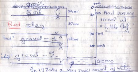
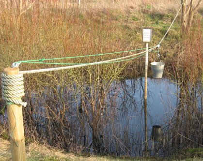
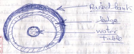
Like an "unlined circular shellhole", it is 10 metres
wide and 2.9 metres deep. On construction in July 2003,
20 cms of rich earth,
50 cms of red clay and 30 cms of red gravel were penetrated, the bottom
lying in white gravel. The well never ran dry in the first 10 years,
always showing the
top of the watertable. A monitor scale is fixed at the well centre.
When the field floods, the scale reads 290-330 cms. At the end
of a months-long drought in Oct 2003, the scale read 45 cms. The
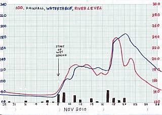
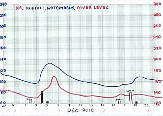
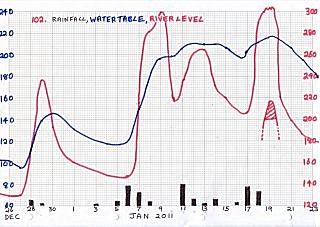
watertable level is recorded every day, and graphed with
river level and rainfall, see Flooding on
Dorset Stour - graphs by year. In dry weather in summer the well
is occasionally pumped to fill a nearby shallow pond (which eventually
seeps back into the groundwater again). The well level drops, but
always returns to its previous level in under 5 hours. In very cold
weather, ice forms on the water surface. If no rain falls for several
days, the watertable drops, removing support for the ice, which breaks
under its own weight.
The well is surrounded by a half-ring of spoil,
(a Sanctuary)
obtained when digging the well. This is now densely vegetated
with grass and wild flowers. The spoil stands above any flood level,
and is now planted with interesting trees - walnut, birch, spindle, rowan,
goat willow and a wayfaring tree. On the perimeter of the well are planted
three white willows, which are now sizeable trees.
In 2004 the Well was used to supply water for 300 4-year oaks growing in
the nearby Nursery in 10 litre pots. All the oaklings grew from acorns
from the Major Oak in Sherwood Forest harvested in 2000. Later that year
these were planted out
into the surrounding 6 acre plantation. The Well is called Bob's Well
after the driver of the mechanical digger who took his life in his hands
during the excavation - from inside the hole!
|
3394 04mar2013. Well, monitor scale and bucket.
 |
Maintenance.
Max. maint. depth=100 cms. Remove pipe, remove crud with soft brush,
warm water and washing-up liquid. Dry and repaint with green acrylic.
Maintained 14jun2014
Dimensions. Length 3.0 metres. ID 50mms. Scale 0.0 to 3.0.
|
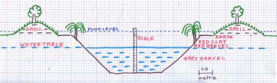
Xsec
Well cross-section, like an "unlined circular shellhole",
10 metres diameter, 2.9 metres deep, soil, clay and gravel underneath,
surrounded by spoil heap.
 |
|
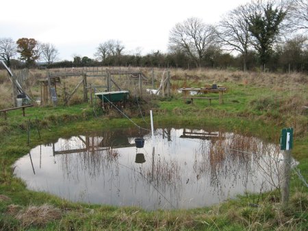
0358 21nov2007.
The Well at Bear Mead Plantation. Level=180.
 |
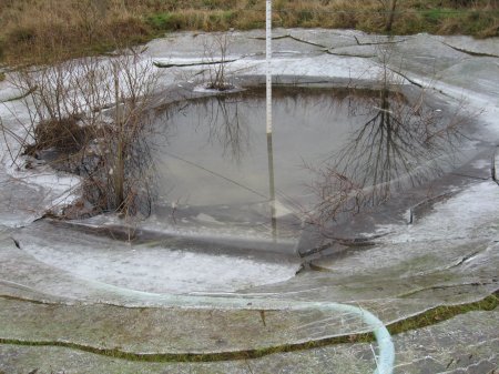
2182 14jan2010. Level=130.
Heavy ice which broke as the level dropped.
 |
Lev2988 Floodplain of the Dorset Stour near the Well
Here the floodplain is about the widest on the river.
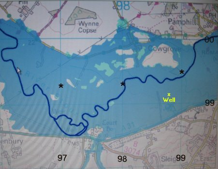 |
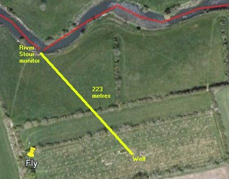
Loc April 2007. Location of Well on floodplain relative
to monitor on
River Stour at Bear Mead. Floodplain is 1000 metres wide at this point.
 |
Typical changes of the Well level (blue)
showing rainfall (black) and river level (red)
over a 3 month period.
(Summer drought 75 cms to winter wet 215 cms = 140 cm change).
|
Watertable height in Well - monthly average over 2003-2013.
Monthly position of 20 Floods recorded in this period.
|
(Bear Mead closed to vehicles November-March due to soft surface)
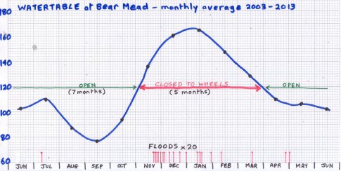 |
  Watertable at Bear Mead, Dorset - Average cms above datum
   2003 '04 '05 '06 '07 '08 '09 '10 '11 '12 '13 '14  Average
Jan   - 172 129 114 202 185 159 184 178 118 207      165
Feb   - 140 110 116 179 163 181 164 144  93 181      147
Mar   - 133  86 114 164 152 145 174 107  87          129
Apr   - 134 100 107 108 123  92 146  81 100          110
May   - 115  89 104 117 133  96  91  70 150          107
Jun   -  93  92 107 116 143  97  77  65 139          103
Jul   -  95  84  97 162 150  95  70  62 174          110
Aug  55  82  71  72 119 107 104  69  73 115           87
Sep  49  77  51  59  88 102  72  73  80 118           77
Oct  48 130  65  86  81 108  68  90  68 198           94
Nov 104 121 123 142 114 181 176 120  74 209          136
Dec 158 125 144 194 175 158 211 113 110 214          160
Watertable when flooded 290-330 approx.
|
FLOODS |
2003 none |
2004 none |
2005 Dec03 |
2006 Nov26, Dec31 |
2007 none |
2008 Jan16, Mar17, Dec15 |
2009 Feb10, Nov30, Dec04, Dec09 |
2010 Jan18 |
2011 none |
2012 Apr27, May01, Jul08, Nov21,23,25, Dec22 |
2013 Jan14,29, Dec25 |
2014 Jan02,05,07,09 Feb07,09,14,16 |
TOTAL=28
|
Floods at Bear Mead - Distribution over 10 years - largest gaps
36 and 27 months

|
|
From |
Well Diary |
by Rosie Palmer |
---------2003-----------
21 Jul John continued, withmy help, to fiddle with his
Heath Robinson contraption, but with a few enhancements bought from B&Q
including a longer rope (30 m) for the pulley system. The first was a bit
too short! There was a case for O level Physics too regarding the bucket!
All this fiddling took ages but it is almost working now. 2 dragonflies
showing interest in the pond, the female appeared to be laying eggs on
the bits of floating greenery and even on the first pulley rope! I saw
a water boatman too!
20 Jul John fiddled around with his Heath Robinson
water collection contraption over the pond for ages.
19 Jul We went to the field and I chucked in the pond: 6 bunches of Hornwort
(from garden ponds #2 and #3), a few cuttings of watermint from our ponds
in the garden and 1 bog bean cutting. The cuttings had roots on them. No
change in pond water level even though we have had about 10mm of rain in
the last few days (level c 6.5)
13 Jul ....Yet another hot, sunny day. A drought? John fixes a water
measurer in centre of pond, and plonks the water starwort in the bottom.
I chuck in some bog bean cuttings from our Front Garden pond which had
roots on them. Will they eventually root into the sides.
12 Jul ...Bob was landscaping the pond. There is now a raised area
on the East side.
 |
Bought 4 Starwort plants from Haskins.
11 Jul The lads filled in the bare hole and then dug the round pond,
10 yds in diameter. The middle is probably about 6ft deep. There is about
2.5 ft of water in the bottom due to reaching the water table. There is a
ledge all the way round. John's diagram of the bore hole:
09 Jul .....Now we are going to have a pond! Bob dug a very deep hole
where the pond will be - on the East side of the pots enclosure-to-be
(126 ft x 30 ft). The pond will be roughly 10 yds x 10 yds. [The deep hole
is to find out if the water table has been reached].
|
|
Compiled, formatted, hyperlinked, encoded,
and copyright © 2013, John Palmer,
 All Rights Reserved. All Rights Reserved.
|