Updated 11 June 2014
|
Dorset Stour - Recording Stations
|
|
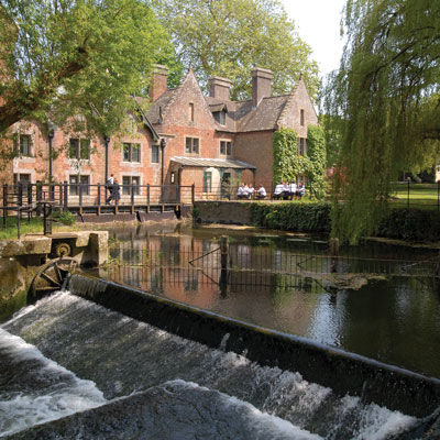
Dorset Stour - Canford sluice.
|
Measuring the delay between rain falling and level
pulse arriving at different places along a river.
Approx. calibration between these places and Bear Mead.
Transit speeds calculated from distance along the river.
Dorset Stour used over 47 miles. Data from
Environment Agency Level recording stations,
BBC weather radar records,
and Google Earth tools.
|
Recording Stations along Dorset Stour:
Gillingham,Hammoon, Blandford, Wimborne.
Gillingham-Hammoon=21.13 miles (15.6 hours)
Hammoon-Blandford=10.76 miles (4 hours)
Blandford-Bear Mead=11.92 miles (12.6 hours)
Bear Mead-Wimborne=3.23 miles (3.2 hours)
Total=47.04 miles, 35.4 hrs along riverer.
|
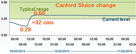
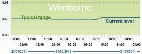
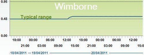
Effect of raising Canford sluice
|
Sluice at Canford School.
 |
River rises 32 cms in 3 hours as sluice is raised
at 1100 on 09 Jun 2014.
River rises 5 cms in 2 hrs as sluice is raised
at 1200 on 23 Mar 2011.
River rises 6 cms in 2 hrs as sluice is raised
at 1200 on 19 Apr 2011.
|
Compiled, formatted, hyperlinked, encoded,
and copyright © 2011, John Palmer,
 All Rights Reserved. All Rights Reserved.
|