Updated 28 Jan 2015
|
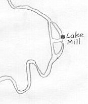
Finding Lake Mill
|
|
Finding Lake Mill |
at SY-9960-9910 in Corfe Mullen, Dorset
Lat 50.791467°N, Long 2.007042°W |
 |
Not to be confused with the preserved "Mullens Mill"
at SY-973-985, 2.6 km to the West in Corfe Mullen.
|
NGR: SY-9960-9910
|
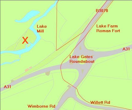
The now-lost "Lake Mill" once stood at SY-9960-9910, about 0.92 miles SW of
the Minster at Wimborne, Dorset, and close to Lake Gates roundabout
on the A31.
It is likely the parish was named after Lake Mill (Saxon) rather than
Mullens Mill (medieval) further West.
Clues on Lake Mill's location are found on
archived Inclosure maps dated 1786 and 1813. The Mill was driven by a
now-extinct loop of the Dorset Stour, called the "Lake Mill Stream"
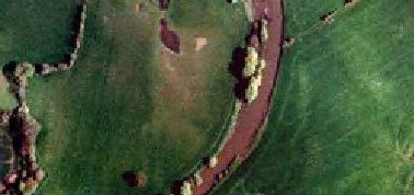
in 1786,1811,1813 and 1890 maps. The 1786 map shows a mill lake and
possible leats, in figure-of-eight shape. These are now heavily
overgrown. A reference suggests Lake Mill was once called
Gillingham's Mill. A Survey of Kingston Lacy made in 1606 records a
William Gillingham as a free tenant who paid 23d rent for water course
to his mill at Lake. This William was probably the grandfather of
Roger Gillingham (born Cowgrove) who died in 1695 (see below).
See my transcription of the
Will of Roger Gillingham
dated 2 July 1695.
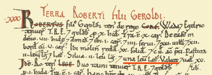
Domesday Book (1086) values Lake Mill at 20 shillings, among the top
5% in value in Dorset (282 mills).
Enquiries: contact 
|
Lake Mill 1786
|
See
1841 Census for Canford
HO287-03 Enumeration District 2
Registrar's District of Canford & Kinson
1841 Census for Canford Magna (part of)
"All that part of the Parish of Canford which lies to the west of
the Turnpike Road from Wimborne to Poole commencing at Canford Bridge
as far as Darby's Corner and from thence to the Boundaries of the
Parish of Corfe Mullen bounded on the south by the Turnpike Road from
Poole to Blandford and on the west by the Parish of Corfe Mullen
comprising Merley, Ashington and part of Rushcombe Bottom."
1841 Census for Canford Magna
4; Lake Mill; James BRADLEY     35 Ag Lab;   Y;
4; Lake Mill; Sarah BRADLEY     25 ;         Y;
4; Lake Mill; William BRADLEY    9 ;         Y;
4; Lake Mill; Rose Ellen BRADLEY 8 ;         Y;
4; Lake Mill; Emma BRADLEY       6 ;         Y;
4; Lake Mill; Mary Jane BRADLEY  4 ;         Y;
4; Lake Mill; Mary PAINTER      55 ; Illegible;
1851 Census for Canford
96; Lake Mills; James BRADLEY;    H;   M; 50; Ag Lab; Dorset;shroten;
96; Lake Mills; S. BRADLEY;       W;   M; 38;         Canford;
96; Lake Mills; W BRADLEY;        Son; U; 19; Ag Lab; Canford;
96; Lake Mills; Mary Jane BRADLEY Dau; U; 14;         Canford;
96; Lake Mills; D. BRADLEY;       Son;     8; Scholar; Canford;
96; Lake Mills; Mary PAINTER;     Wife's mother; U; 70; Pauper; Canford;
1861 Census for Canford
56; Illegible; James  BRADLEY  Head  Mar 59  Ag. Lab.  Shroton?Shipton;
56; Illegible; Mary   BRADLEY  Wife  Mar 34            Wimborne;
56; Illegible; David  BRADLEY  Son   UM  14  Ag. Lab.  Canford;
56; Illegible; Sarah  BRADLEY  Dau   UM  7m            Canford;
|
---------------
A CALENDAR OF DORSET DEEDS. 175
15 Jan. 1774. Talbot, John, miller, of Lake Mill, Great Canford.
Hanham, Sir William. Surrender of cottage.
---------------
In the Calendar of Dorset Deeds published in the Proceedings of the Dorset
Natural History the following reference to Stephen Gillingham of Spraggs (sic)
Mill appears.
Volume L 1928 p 219
Deed No. 1798 Dated 1854 September 30
Declaration of Ann Stone of Mere widow aged 60 a daughter of Stephen
Gillingham formerly of Spraggs Mill in Cann miller
Other millers mentioned this Calendar are
John Talbot John miller of Lake Mill Great Canford
--------------------------
"For a long
while this branch was known only as far as Cogdean from
Hamworthy across Lytchet Heath; but in the year 1847-
1848, its line was traced out from Lake Mill, one mile
West of Wimborne, across the water meadows, the river
Stour, and through the Park of Kingston Lacy, to
Badbury."
--------------------------
|
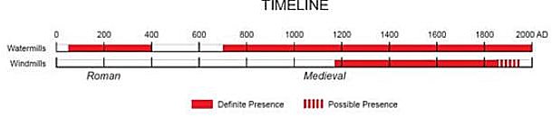
The mill referred to in 1086 is probably Lake Mill,
a watermill (there were no windmills in England for another 100 years).
"Mullens Mill" on the A31 next to the Coventry Arms is medieval only and
has an inscribed date "AC 1714".
Lake Mill lies on the parish boundary (laid out in Saxon times)
and next to the old road for transport of product.
The Parish logo should represent Lake Mill, not Mullens Mill.
From
Dorset OPC:
"Called 'Corf' in the Domesday Book of 1086, by 1176 it was being refered
to as 'Corf Molyn' going through several variations to the present day.
Mullen is derived from the Old French for mill, refering to the old mill on
the river Stour which at the time of Domesday was valued at 20 shillings,
a considerable amount at the time".
If this is correct, it is likely Corfe Mullen derives
its name from Lake Mill, not 'Mullens Mill'.
|
Parish logo
 |
|
 |
Place: Corfe [Mullen] Hundred: Cogdean County: Dorset
Total population: 28 households (quite large).
Total tax assessed: 10 geld units (very large).
Taxable units: Taxable value 10 geld units.
Value: Value to lord in 1086 �15. Value to lord c. 1070 �15.
Households: 12 villagers. 12 smallholders. 4 slaves.
Ploughland: 10 ploughlands (land for). 1 lord's plough teams.
5 men's plough teams.
Other resources: 7.5 lord's lands. Meadow 102 acres. Pasture
2 * 2 leagues. Woodland 2 * 1 leagues.
1 mill, value 1.0.
Lords in 1066: Aethelric; Wada son of Aethelgyth.
Lord in 1086: Robert son of Gerald.
Tenant-in-chief in 1086: Robert son of Gerald.
Phillimore reference: 30,1
|
|
REF. 3
|
LAKE FARM: mentioned 1575. Lake Mill was called
Gillingham's Mill.
From: "Place-names of Dorset" by A D Mills, Part 2, page 3,
Parish of Canford Magna.
LAKE FARM (SZ999989), La(c)ke 1565 Comm, Lake 1575 Saxton, e17 BRA et
passim, no doubt the home of John atte Lake 1332 SR, cf John Lake
1374 MinAcct, Gillingham's Mill now Lake Mill, Lake Mill Stream,
Over Lake 1822 EnclA, v. lacu 'a stream, a water-course', atte, uferra;
the farm stands on a small tributary of River Stour called Chelwell
Water 1822 EnclA.
Comm=Exchequer Special Commissions in PRO; BRA=Publications of the
British Records Association; MinAcct=Minister's Accounts in PRO;
EnclA=Unprinted Enclosure Awards in DRO
|
|
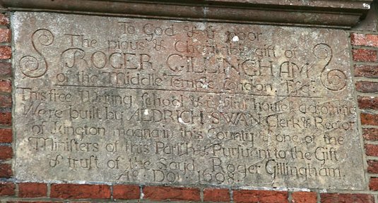
Pamphill First School
First built in 1695, the school was only the central part of the building,
meaning a very low capacity, with adjoining almshouses on either side.
It was built through the will of Roger Gillingham of the Middle Temple,
who left property in Bedfordshire, Hackney and Stepney to trustees, in
assurance that they would raise �400 for a close next to Pamphill Green.
It has continued over the years with the almhouses becoming classrooms and,
closer to now, building work to make more room. An inscription on the
outside of the school reads:
To God & ye poor
The pious & charitable gift of
ROGER GILLINGHAM
of the Middle Temple, London, Esq.
This free writing school & ye almshouse adjoining
Were built by ALDRICH SWAN clerk & Rector
of Kington Magna in this county & one of the
Ministers of the parish & Pursuant to the Gift
of Trust of the said Roger Gillingham
Ao Doi 1698
|
|
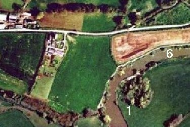
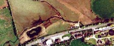
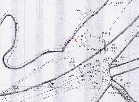
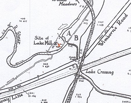
1888 Ordnance Survey
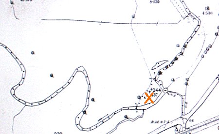
2013 - Lake Mill is 50m West of "Scheduled Monument" area around
Lake Farm Roman Fort
|
1989 Ordnance Survey
Park on wide verge of Lake Gates roundabout, A31.
Follow public footpath sign through hedge
Turn left over wide private wooden bridge
Follow down stream, through gate, over narrow
wooden footbridge
Follow path through dense undergrowth to
small sluice with stone sides
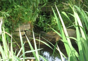
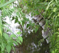
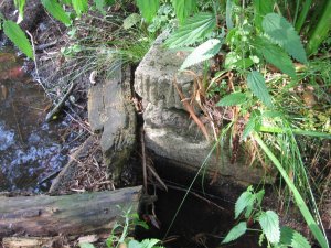
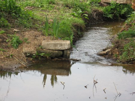
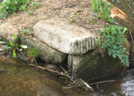
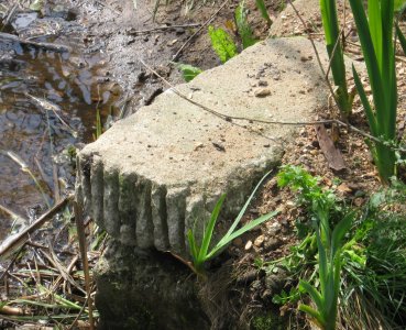
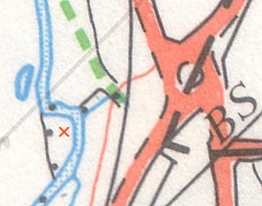
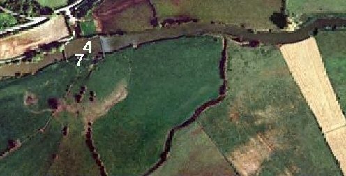
X Location of Lake Mill (very heavily overgrown).
|
Stonework around remains of leat "crossbar"
at location of now-vanished Lake Mill.
|
1
Publication date: 1890 |
Citation:'England - Dorset: 034/NE', Ordnance Survey 1:10,560 - Epoch 1 (1890). |
www.british-history.ac.uk |
Date accessed: 02 March 2012. |
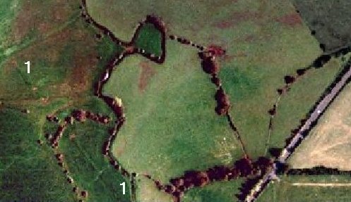
Supporting documents: Historical Legend - Scale 1:10560 County Series
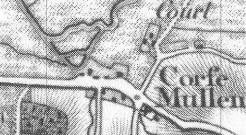
2
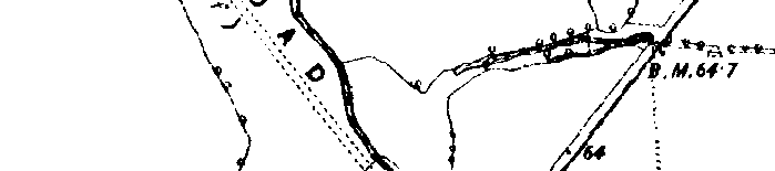
1811 OS Map
1. This map was first drawn 1811, but later additions (such as the railway) were added up to 1870.
2. The Southern branch of Stour at Eye Mead looks as wide as the Northern branch.
3. Has the first mention of a Bridge at Eye.
4. A curious "road" (going nowhere) at the side of the straight road to Wimborne, is this the remains of the "old road"?
5. There is no definite sign of Lake Mill.
6. There is a road reaching the Stour close to the point of divergence of Lake Mill Stream
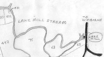
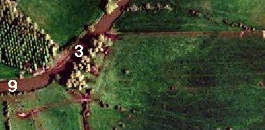
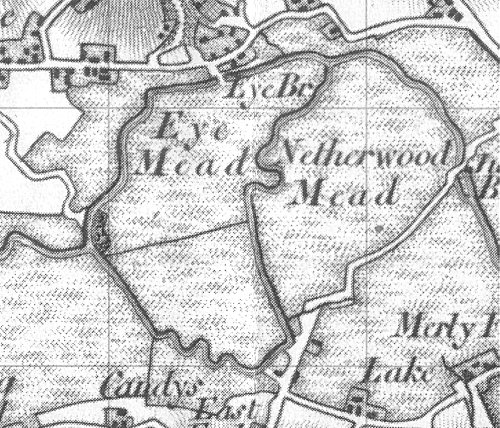
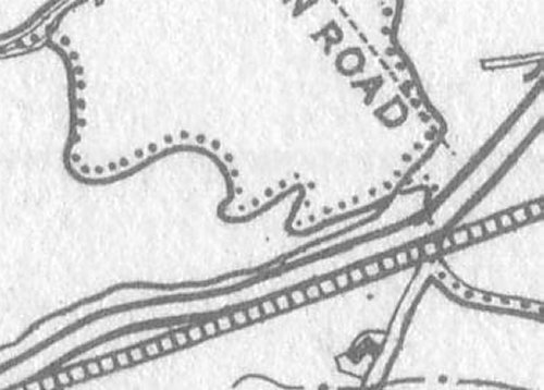
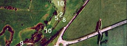
3
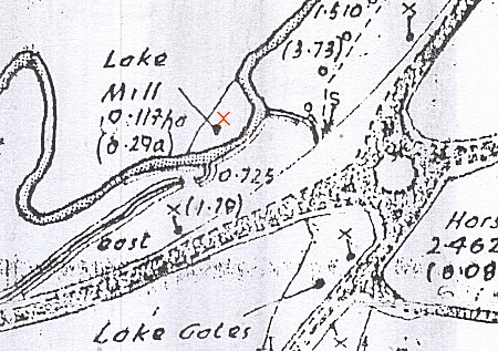
1813 Corfe Mullen Inclosure Map
There is today no trace of the Lake Mill, but on this 1813 map it is shown as being driven by the Lake Mill Stream,
which must have flowed strongly in those days. The road to Wimborne is not the present road, but traces of the old
road can still be seen in the fields. The Parish boundary follows the Mill Stream, showing its importance, but as
this map is a Parish map, details from "across the border" are missing.
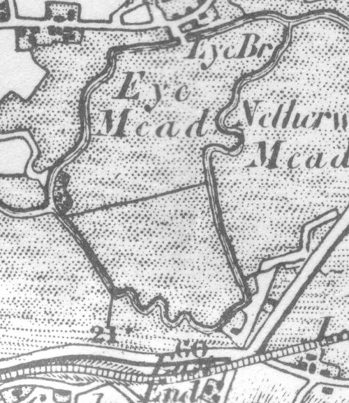
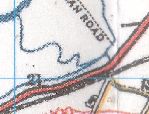
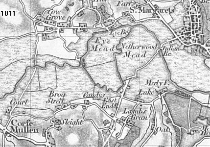
4
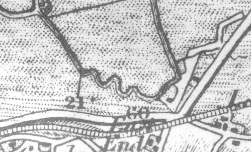
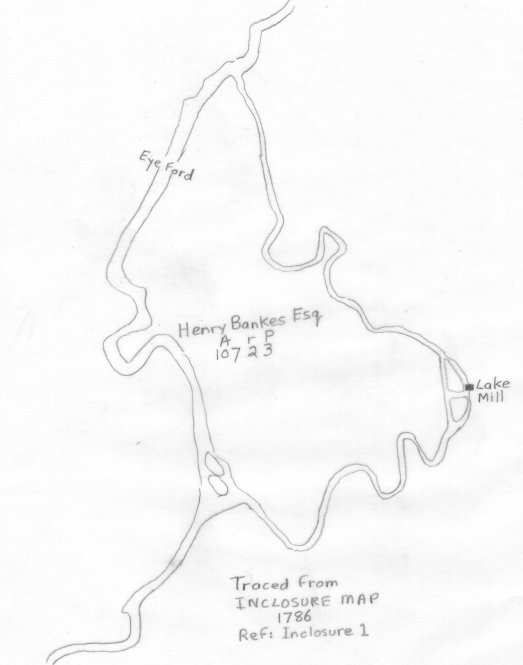
1786 Tracing from an Inclosure Map
Text from the same document:
"...One plot or parcel of land lying and being in Eye meadow Close and Leaze and containing 107 acres 2 roods and
3 perches. Bounded on or towards the East side by a back brook or rivulet running from Lake Mill into the River Stour
- on or towards the South and South west by the Stream or brook running to the said Lake Mill - and on every other
part by the River Stour and two Hooks belonging to the said Henry Bankes called Trendles Holes which were not subject
to common Right".
- There is an accurate area for Eye Mead (in Acres, roods and perches).
- "Eye Ford" is shown near where Eye Bridge is today.
- A well-developed ox-bow is shown on the main river
(which today has "collapsed" to an area of trees on the
North bank).
- The position of Lake Mill is accurately shown, beside two islands in Lake Mill Stream.
- The ox-bow in the Mill Stream has not developed any further since 1786.
- The start of the Mill Stream (next to the two islands) is shown as being quite wide.
- Eye Mead (owned by Henry Bankes in 1786) is one of the few parts of the Bankes' estate to the South of the river,
and was left to the National Trust in 1983.
|
Value of Domesday Dorset watermills
|
| |
|
Only 4 in 282 Dorset watermills (1.4%)
were more valuable than Lake Mill in 1086.
Another 11 mills were the same value (4%).

|
This data has been extracted from:
www.windmillworld.com/watermills/domesday.htm

                   DORSET
All places                           521
--with mills                         189
--with single mill                   133
Places with mill, value =20s          11
Places with mill, value >20s           4

Mills             282
--valued          276.5
--not valued      5.5
Total value       £113.258
--average value   £0.409
|
Mills valued in units of £ = 20s =240d
£ Value band
Place Mills Total Aver 0 1 2 3 4 5 6 7 8 9 10 11 12
(un-named) 1 0.50 0.50 1
Abbotsbury 2 0.81 0.40 2
Acton 1 0.62 0.62 1
Affpuddle 2 0.75 0.37 2
Allington 1 0.75 0.75 1
Alton Pancras 1 0.75 0.75 1
Askerswell 2 0.35 0.17 2
Athelhampton 1 0.28 0.28 1
Beaminster 3 0.20 0.07 3
Bere Regis 1 1.00 1.00 1
Boveridge 1 0.30 0.30 1
Bradford Abbas 1 0.75 0.75 1
Bradford Peverell 2 1.00 0.50 2
Bredy 1 0.50 0.50 1
Briantspuddle 1 0.37 0.37 1
Bryanston 1 1.00 1.00 1
Buckland Ripers 1 1.00 1.00 1
Burleston 1 0.17 0.17 1
Burton Bradstock 8 4.15 0.52 8
Canford Magna 2 0.75 0.37 2
Catherston Leweston 1 0.01 0.01 1
Cattistock 1 0.06 0.06 1
Cerne 1 0.50 0.50 1
Cerne 1 0.25 0.25 1
Cerne 1 0.08 0.08 1
Cerne 1 0.17 0.17 1
Cerne Abbas 1 1.00 1.00 1
Chaldon Herring and West Chaldon 1 0.50 0.50 1
Chardstock 2 1.00 0.50 2
Charlton Marshall 2 2.02 1.01 2
Charminster 1 0.30 0.30 1
Cheselbourne 1 0.75 0.75 1
Chilcombe 1 0.25 0.25 1
Child Okeford 1 0.50 0.50 1
Child Okeford 2 1.00 0.50 2
Chilfrome 1 0.15 0.15 1
Compton Abbas 1 0.21 0.21 1
Corfe Mullen 1 1.00 1.00 1
Corscombe 1 0.25 0.25 1
Cranborne 4 0.90 0.23 4
Cruxton 1 0.50 0.50 1
Didlington 1 0.63 0.63 1
East Stoke 1 0.75 0.75 1
East and West Pulham 1 0.17 0.17 1
East and West Stour 1 0.42 0.42 1
East and West Stour 3 1.50 0.50 3
Edmondsham 1 0.13 0.13 1
Edmondsham 1 0.25 0.25 1
Fifehead Magdalen 2 1.13 0.65 2
Fifehead Neville 1 0.17 0.17 1
Fifehead St Quintin 1 0.25 0.25 1
Fontmell Magna 3 0.58 0.19 3
Fordington 12 6.25 0.52 12
Frampton 2 1.00 0.50 2
Frome Billet 1 0.25 0.25 1
Frome St Quintin 1 0.20 0.20 1
Frome Vauchurch 1 0.50 0.50 1
Frome Whitfield 1 0.25 0.25 1
Galton 1 0.63 0.63 1
Graston 1 0.37 0.37 1
Great Crawford 0.25 0.13 0.52 1
Great Crawford 0.75 0.45 0.60 1
Gussage All Saints 1 1.25 1.25 1
Hammoon 1 0.37 0.37 1
Hanford 2 0.80 0.40 2
Higher and Lower Bockhampton 1 0.25 0.25 1
Higher and Lower Sturthill 1 0.31 0.31 1
Hilton 1 0.08 0.08 1
Hinton Martell 3 1.00 0.33 3
Hinton St Mary 1 0.50 0.50 1
Hooke 1 0.30 0.30 1
Horton 2 0.75 0.37 2
Hurpston 1 0.08 0.08 1
Ilsington 1 0.00 0.00 -
Iwerne Courtney 2 0.60 0.30 2
Iwerne Minster 3 0.85 0.28 3
Kinson 1 0.25 0.25 1
Knowlton 1 0.63 0.65 1
Langton Long Blandford 1 0.92 0.92 1
Lazerton 1 0.10 0.10 1
Little Cheselbourne 1 0.13 0.13 1
Littleton 1 0.37 0.37 1
Litton Cheney 1 0.13 0.13 1
Loders, Uploders and Loders Lutton 1 0.15 0.15 1
Loders, Uploders and Loders Lutton 2 1.17 0.58 2
Long Bredy 1 0.30 0.30 1
Long Crichel 1 1.00 1.00 1
Lyme Regis 1 0.16 0.16 1
Maiden Newton 2 1.00 0.50 2
Manston 2 0.60 0.30 2
Mapperton 1 0.25 0.25 1
Mappowder 2 1.60 0.80 2
Martinstown 1 0.07 0.07 1
Melbury Abbas 4 0.76 0.19 4
Melbury Bubb and Osmund 1 0.25 0.25 1
Milborne St Andrew 1 0.13 0.13 1
Milborne Stileham 1 1.25 1.25 1
Milton Abbas 1 0.75 0.75 1
Milton on Stour 1 0.05 0.05 1
Milton on Stour 4 0.31 0.08 1
Morden and East Morden 0.5 0.05 0.05 1
Morden and East Morden 1 0.19 0.19 1
Morden and East Morden 1 0.31 0.31 1
Moreton 1 0.15 0.15 1
Mosterton 1 0.37 0.37 1
Moulham 1 0.03 0.03 1
Nether and Over Compton 1 0.50 0.50 1
Netherbury 2 0.75 0.37 2
Okeford Fitzpaine 1 0.25 0.25 1
Osmington 1 0.25 0.25 1
Owermoigne 1 0.30 0.30 1
Petersham 1 0.29 0.29 1
Piddle 1 0.17 0.17 1
Piddle 1 0.17 0.17 1
Piddletrenthide 3 3.00 1.00 3
Poorton 1 0.00 0.00 -
Portesham 1 0.04 0.04 1
Povington 1 1.25 1.25 1
Powerstock 2 0.15 0.07 2
Puncknowle 1 0.63 0.63 1
Ranston 1 0.15 0.15 1
Ringstead 0.5 0.20 0.20 1
Rushton 1 0.00 0.00 -
Shapwick 8 5.50 0.69 8
Sherborne 4 1.35 0.34 4
Sherborne 8 1.55 0.19 8
Shillingstone 1 1.18 1.18 1
South Perrott 1 0.10 0.10 1
Spetisbury 1 0.63 0.63 1
Stafford 1 0.25 0.25 1
Stalbridge 1 0.75 0.75 1
Stoborough 1 0.00 0.00 -
Stockland 3 0.15 0.05 3
Stoke Abbott 1 0.25 0.25 1
Stoke Wake 1 0.05 0.05 1
Stoke Wallis 1 0.17 0.17 1
Stourpaine 1 0.15 0.15 1
Stourton Caundle 1 0.15 0.15 1
Stourton Caundle 1 0.45 0.45 1
Sturminster Marshall 2 1.40 0.70 2
Sturminster Newton 4 2.19 0.55 4
Sutton Waldron 1 0.37 0.37 1
Swyre 1 0.80 0.80 1
Sydling St Nicholas and Up Sydling 1 0.25 0.25 1
Sydling St Nicholas and Up Sydling 2 0.37 0.18 2
Tarrant 1 0.13 0.13 1
Tarrant 1 0.13 0.13 1
Tarrant Crawford 1 0.25 0.25 1
Tarrant Keyneston 2 1.50 0.75 2
Tarrant Monkton 1 0.25 0.25 1
Thornford 1 0.63 0.63 1
Todber 1 0.50 0.50 1
Toller Fratrum and Porcorum 1 0.13 0.13 1
Tolpuddle 2 1.00 0.50 2
Trill 2 0.71 0.35 2
Turners Puddle 1 0.50 0.50 1
Up Cerne 1 0.75 0.75 1
Walditch 1 0.19 0.19 1
Warmwell 1 0.25 0.25 1
Warmwell 1 0.25 0.25 1
Watercombe 0.5 0.20 0.20 1
Waterston and Lower Waterston 1 0.15 0.15 1
West Knighton 2 0.60 0.30 2
West Milton 1 0.27 0.27 1
Wey 1 0.75 0.75 1
Wey 2 1.00 0.50 2
Wey 2 1.60 0.80 2
Wey 3 1.75 0.58 3
Wey 3 1.88 0.63 3
Wimborne 1 0.10 0.10 1
Wimborne St Giles 0.5 0.06 0.06 1
Wimborne St Giles 1 0.00 0.00 -
Wimborne St Giles 1 0.37 0.37 1
Winterborne 1 0.25 0.25 1
Winterborne 1 0.06 0.06 1
Winterborne 1 0.07 0.07 1
Winterborne 4 2.50 0.63 4
Winterborne Stickland 1 0.63 0.63 1
Witchampton 1 0.50 0.50 1
Witchampton 1 0.25 0.25 1
Woodsford 1 0.30 0.30 1
Wootton Fitzpaine 1 0.06 0.06 1
Wootton Fitzpaine 2 0.75 0.37 2
Worgret 0.5 0.00 0.00 -
Worgret 0.5 0.50 0.50 1
Worth Matravers 1 0.37 0.37 1
Wraxall 1 0.25 0.25 1
Wynford Eagle 1 0.50 0.50 1
Yetminster 2 0.25 0.13 1
24 47 39 39 6 61 26 13 5 1 11 1 3
Sub-totals in each value band
|
|
----Anyone with more details for publication on this webpage,
please email  ---- ----
Some emailers have requested that their emails remain anonymous
--------------------------
From Geoff Moy on 24mar2014
Dear John
As a person christianed in St. Huberts and of a family who for 150 years
tenanted or owned Lake Farm, I am interested in your information regarding
Corfe Mullen.
The answer to your problems regarding Lake Mill,
is the fact that the
blank area beyond the Corfe Mullen parish boundary is the powerful parish
of Great Canford.
Until the World War I when Canford Estate was broken up, they owned land
in Corfe Mullen including the land south of the Mill Race.
I have many documents.
Perhaps we should talk.
Mr. Geoffrey Moy
My diary is full until after 7 April 2014.
Yours truly
G Moy
--------------------------
On 10oct2013 [Anonymous] wrote:
Thank you for the additional information. You may well be correct that the
village was named after the mill. The root of mill in most European
languages is "molin" or variations of this. There is also evidence of
Romans using watermills in Britain so the proximity to a Roman fort is
interesting.
I hope that you can generate some local interest in the mill site as there
certainly seems to be a lot of early settlement history in the area even
pre-Roman. Have you contacted any local archaeological groups to see if
they would be interested in a dig project?
Do let us know how you get on
[Anonymous]
-----------------------
On 19jul2013 [Anonymous] wrote:
I have had a reply from one of the watermill experts:
"I'm afraid I can't help you about Lake Mill. Mr Palmer seems to know more
about it than anyone else already!"
So it seems that you have made a 'new' discovery! May we mention this find
on our blog and refer people to your website pages? Is the mill in the
parish of Corfe Mullen or Canford?
We are very impressed with your research. Perhaps it was a farm mill,
milling grain for animal feed or for the needs of the farmer and his family.
Farm mills are quite common in the South West. The mills at Corfe Mullen
and Canford Magna seem much larger and probably more profitable as mills
for a wider area.
We are always pleased to learn about the location of vanished mills.
Please may we add the information about your mill to our Mill Index and
Mill People Database? Would you be able to send us copies of images that
show any of the remains such as the leat and information about it. Are
there any visible remains of the mill or even an impression on the land
that it was once there?
[Anonymous]
---------------------------
|
|
Archaeology
Lidar has many applications in the field of archaeology including aiding
in the planning of field campaigns, mapping features beneath forest canopy,
and providing an overview of broad, continuous features that may be
indistinguishable on the ground. Lidar can also provide archaeologists with
the ability to create high-resolution digital elevation models (DEMs)
of archaeological sites that can reveal micro-topography that are otherwise
hidden by vegetation. LiDAR-derived products can be easily integrated into
a Geographic Information System (GIS) for analysis and interpretation. For
example at Fort Beaus�jour - Fort Cumberland National Historic Site, Canada,
previously undiscovered archaeological features below forest canopy have
been mapped that are related to the siege of the Fort in 1755. Features that
could not be distinguished on the ground or through aerial photography were
identified by overlaying hillshades of the DEM created with artificial
illumination from various angles. With lidar the ability to produce
high-resolution datasets quickly and relatively cheaply can be an advantage.
Beyond efficiency, its ability to penetrate forest canopy has led to the
discovery of features that were not distinguishable through traditional
geo-spatial methods and are difficult to reach through field surveys, as in
work at Caracol by Arlen Chase and his wife Diane Zaino Chase. The intensity
of the returned signal can be used to detect features buried under flat
vegetated surfaces such as fields, especially when mapping using the
infrared spectrum. The presence of these features affects plant growth and
thus the amount of infrared light reflected back. In 2012, Lidar was used
by a team attempting to find the legendary city of La Ciudad Blanca
in the Honduran jungle. During a seven-day mapping period, they found
evidence of extensive man-made structures that had eluded ground searches
for hundreds of years. In June 2013 the rediscovery of the city of
Mahendraparvata was announced.
Wikipedia
|
|
|
By the time of the Domesday Book (1086), which records over 5,000 watermills
(some clearly long established), almost all communities had easy access to
one.
Windmills were introduced to England in the mid to late 12th Century.
DESCRIPTION
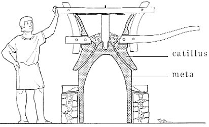
Watermills
Many mills were situated on a millstream or leat, an artificial channel
that allowed the flow of water that drove the mill to be managed.
In other cases the mill stood on a natural watercourse,
modified with a dam and a bypass channel. Sometimes a weir
was constructed to direct water into the mill race/bypass channel.
The millstream had three parts: the millrace above the mill, the wheel-race
flowing past it, and the tailrace below. Millraces varied from less than a
metre wide and a few metres long to over 10m wide, several metres deep and
a kilometre or more in length. The millrace often fed a millpond, and one
of the commonest surviving features is the dam built to retain such, the
size of the pond and dam varying with the topography and the size of the
mill to be powered. The water then passed into the wheel-race, which was
frequently lined with timber or stone, and later brick, where it was
directed onto the waterwheel(s). Sometimes there was a bypass channel to
carry water when the mill was not in use. Once the water had passed the
wheel it was directed back to the watercourse via the tailrace, which was
generally shorter than the millraces. Sometimes there was a millpond below
the mill that would retain water and so even out the flow downstream when
the mill was operating.
|
|
Mullens Mill, in a good state of preservation, is medieval/C18.
("The Old Mill" was auctioned (but not sold) by Symonds & Sampson
at Digby Hall, Sherborne on 25 Oct 2013 2pm. Guide price £750,000.)
OS map 1811, early version
|
2013 map, showing modern mill layout.
|
From:
Britishlistedbuildings.co.uk
CORFE MULLEN,SY 99 NE,MILL STREET,(North),10/14,Mullens Mill House,Restaurant
- Grade II listed
Watermill and house attached, now house and restaurant. Of medieval origin
but mainly early C18 with early C19 extension and details. Brick walls of
English bond, cambered heads to the older openings. Tile roof, with stone
slates to the lowest courses. The main north-south structure of the mill is
of two storeys and attic, and rests on a base of stone walling, pierced by
two water channels (the arch of one having a keystone inscribed AC 1714).
The mill was extended at the north end as a timber framed building, with
boarded walls above a cart shed open ground floor, now filled with
brickwork. The south end contains the house as a cross wing, with a
symmetrical south front of two storeys three windows. Casements throughout,
the house having two early C19 bays (one replacing the former central
doorway). Plain doorways set in the long eastern elevation. Inside, the
north channel contains a water-wheel. RCHM
Listing NGR: SY-97297-98522
|
|
The late version of this "1811" OS map shows several changes,
the main ones being:
the addition of the Turnpike (1840),
the new Julian's road,
and the new railway (1847).
Two buildings are shown on the Millstream side of the old road.
The downstream is likely to be Lake Mill, the other the miller's house.
More history of this microarea is given in
Fields
|
1811 OS map - early version
 |
1811 OS map - late version
 |
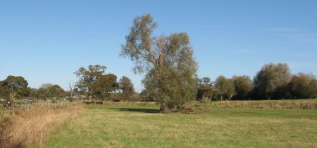
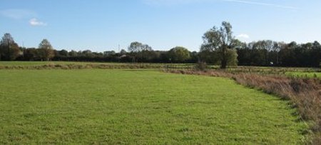
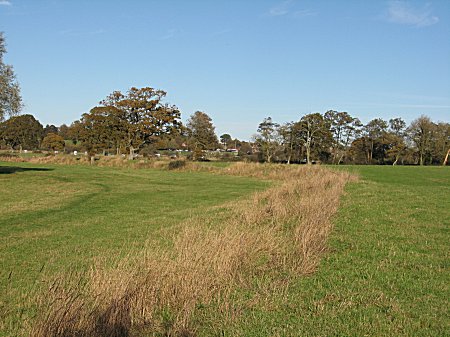
The old Wimborne-Bere road in 2013
Bounded by old Mill Stream and steep edge of old road,
(Netherwood Lane)
might contain Lake Mill and a seperate house.
Grass kept short by sheep.
|
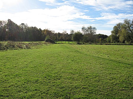
Looking NE
|
Looking SW
|
1893 OS map
 |
1919 OS map
 |
|
A Survey of Kingston Lacy made in 1606 records a
William Gillingham as a free tenant who paid 23d rent for water course
to his mill at Lake. This William was probably the grandfather of
Roger Gillingham (born Cowgrove) who died in 1695
(see family tree).
See my transcription of the
Will of Roger Gillingham
dated 2 July 1695.
|
Records from the Ancestry site

Name:  Gillingham, William
Dates: 1618
Place: General, England
Book:  Wills Proved in the Prerogative Court of Canterbury, and now
       Preserved in the Principal Probate Registry. 1605 to 1619.(Will)
Collection: England: Canterbury - Wills Proved in the Prerogative
       Court of Canterbury, 1605-1619
Text:  1618 Gillingham, William, yeoman, Mores, Honnis, Hants,
       [P.A.B. afterwards of Great Canford, Dorset] 111 Meade

UK, Extracted Probate Records, 1269-1975 about Gillingham, William
Name:  Gillingham, William
Dates: 1615
Place: General, England
Book:  Wills Proved in the Prerogative Court of Canterbury, and now
       Preserved in the Principal Probate Registry. 1605 to 1619.(Will)
Collection: England: Canterbury - Wills Proved in the Prerogative
       Court of Canterbury, 1605-1619
Text:  1615 Gillingham, William, shoemaker, Lake, Canford, Dorset 42 Rudd
|
|
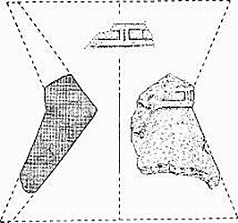
A Roman milling artefact � part of a catillus - was found at
Corfe Mullen in 1942 and is now in Poole Museum.
The fragment, some 16 ins. square, belongs to a mill of Pompeian type.
The catillus was perhaps 2� ft. high, with a simple moulding at
the waist, below which a rough excrescence could be remains of a lug.
|
(24) East End (SY 99 NE). A Pottery-kiln, Pits, Ditches, and Occupation
Debris have been found about 200 ft. above sea level in the railway
ballast pit beside the destroyed Roman road (992983).
A settlement, possibly established in Iron Age 'B' or 'C' and surviving
at least to the mid 4th century, is indicated by storage and rubbish pits
and alleged hut sites observed since 1927, a pottery-kiln, excavated in 1932,
ascribed to c. A.D. 50�60 with contemporary pits and ditches, and possibly
by a late Roman kiln. Early wares, including Continental imports, were
sherds of Hengistbury class B, butt-beakers, Belgic platters, amphorae and
S. Gaulish samian, with metallic-lustred ware of New Forest type indicating
the latest known occupation. Iron slag suggested smelting;
milling on a
commercial or military scale is implied by a piece of upper stone (catillus)
of a Niedermendig lava donkey-mill (see Fig.) in Poole Museum.
One or possibly two pits lined with clay contained carbonized grain, mainly
Spelt wheat.
The stoke-hole of the kiln alone survived (99219830). Its filling and that
of four pits and two ditches some 15 ft. long found within 20 yds. of it,
yielded analogous sherds and an as of Caligula of A.D. 40. Kiln wares
included ring-neck flagons, mortaria, and thin-walled romanized versions of
Durotrigian cooking-pots probably unintentionally oxidized. Six oxidized
vessels (four in B.M.), found together in two rows in 1929, were probably
rejects from a late 3rd or 4th-century kiln producing cooking-pots and bowls
of Gillam's types 147 and 228 (Arch. Ael. xxxv (1957), 180�251). Objects
are in B.M., D.C.M., Poole Museum and Christchurch Museum. (Ant. J. xv (1935),
42�55; Dorset Procs. LXV (1943), 57�8; Procs. Bournemouth Natural Science
Society XLI (1951), 52�3; M. H. Callender, Roman Amphorae (1965), 156.)
From: 'Other Roman Monuments', An Inventory of the Historical Monuments in
Dorset, Volume 2: South East (1970), pp. 592-621.
URL: http://www.british-history.ac.uk/report.aspx?compid=127579
Date accessed: 08 November 2013.
|
|
|
Numbers refer to points in the argument by Ronald Good
about the Stour changing its bed in 1700
and there being a ford at Lake.
From: "The Old Roads of Dorset" by Ronald Good, Page 42: (first published
1940)
|
|
|
 |
 |
 |
 |
10. Remains of Netherwood Lane (pre 1810).
|
|
- Roman Road ran from near Cowgrove to a little West
of Lake Farm, where a minor loop of the river comes close to the present
main road [A31].
- Ogilby [1675], mentions and depicts a road running Westward
from near Canford to "Lakeford".
- Approached
by Weir Lane, there is an old ford just West of, above,
the spot at which the river loop leaves the present main
stream.
- A broad, hedged, approach to
the river where a ford is marked,
there is a substantial iron foot-bridge, Eye Bridge, though there does
not seem to be any sign of a road running to it from the South side.
- Although Lake is now half a mile
from the river both the Roman road and Ogilby suggest strongly that
there was a ford at Lake and if so this can only have been on what
is now the subsidiary loop of the river.
- Between
Ogilby's, 1675, and Taylor's map, 1765, which shows
the river as it is now, the Stour changed its course here, being
naturally or deliberately diverted along its present line leaving the
former, much longer, bed of the river to become gradually reduced by silting
and filling.
- With the loss of Lake ford another
crossing became necessary across the new river, and this
is provided at Eye Bridge.
- The Roman Road
is shown on maps as changing its course hereabouts, but this is not wholly
convincing, and if the Southern leg of the road is produced a little further
north beyond its apparant termination it comes very close to the presumed
site of Lake ford.
- Our idea that the river has changed is strongly
supported, even proved, by the fact that the old river
loop was until 1933, and is still partly, a local government and parish
boundary like the main bed West and East of it....."
|
GOOD independently suggests that the Stour has changed its
bed (though he dates the change to around 1700), and that there was a ford
at Lake. He points out that the "Lake Mill Stream" is still a parish and
local government boundary, but was unaware of the Roman fortress at Lake,
controlling the direction of the Roman roads.
From: "The Old Roads of Dorset" by Ronald Good, Page 42: (first published
1940)
"....On the West side of Wimborne the story is interesting but
complicated.
- Historically it begins with the Roman Road from Badbury to
Hamworthy which ran South-East from near Cowgrove to a point a little West
of Lake Farm, where a minor loop of the river comes close to the present
main road [A31].
- Next, Ogilby [1675], in his description of the road from
Wimborne to Poole (see p 56) mentions and depicts a road running Westward
from near Canford to "Lakeford".
- Again, South of Cowgrove, and approached
by Weir Lane, there is an old ford just West of, that is to say, above,
the spot at which the river loop just referred to leaves the present main
stream.
- Finally, South of Pamphill there is a broad, hedged, approach to
the river where a ford is marked on 6" OS and where, until the Second World
War there was a substantial iron foot-bridge, Eye Bridge, though there does
not seem to be any sign of a road running to it from the South side.
- The
clue to the explanation of all this is that although Lake is now half a mile
or so from the river both the Roman road and Ogilby suggest strongly that
there was a ford at Lake and if so this can only have been on what is now
the subsidiary loop of the river.
- It therefore looks very much as if between
the time of Ogilby, 1675, and Taylor's map, 1765 (see p 53), which shows
the river as it is now, the Stour changed its course here, being either
naturally or deliberately diverted along its present more direct line from
just East of Cowgrove ford to a point South of Stone Park leaving the
former, much longer, bed of the river to become gradually reduced by silting
and filling.
- If this is indeed so then with the loss of Lake ford another
crossing became necessary across the new river south of Pamphill, and this
is provided at Eye Bridge.
- Two more points should be noticed. The Roman Road
is shown on maps as changing its course hereabouts, but this is not wholly
convincing, and if the Southern leg of the road is produced a little further
north beyond its apparant termination it comes very close to the presumed
site of Lake ford.
- Second, our idea that the river has changed is strongly
supported, and some may think even proved, by the fact that the old river
loop was until 1933, and is still partly, a local government and parish
boundary like the main bed West and East of it....."
|
|
 |
The Puddletown and Wimborne Trust.
This Trust, set up by an Act of 1840 (3,4 Vict.c.xxiii)
was the last of the ordinary Dorset trusts but one of the most
important and interesting.
...it resulted in considerable loss to its chief promoter,
the then owner of Charborough and Member of Parliament for Wareham,
Mr J S W Sawbridge Erle Drax. This was because it came too late,
for within less than seven years of its completion the railway
from Wimborne to Dorchester through Wareham had taken away much
of its purpose.
The founding Act lists the roads to be covered as
follows. (1) From Wimborne to join the Blandford and Poole
turnpike at Corfe Mullen. This is the road from Wimborne
over Julian's Bridge to the church at Corfe Mullen.
On the town side of the bridge the road took a new
line slightly south of the old;
West of the bridge, as far as the turning to Lake Farm
it was a new version of an old road called
Netherwood Lane, which had already been widened some
thirty years before [ie 1810]; and the mile and a half west
again was a new road."
From: "The Old Roads of Dorset" by Ronald Good, Page 147:
(first published 1940).
|
Looking SW. Road bank of Netherwood Lane on left.
 |
Looking NE. Road bank of Netherwood Lane on right.
 |
|
An email from Geoff Moy let me meet him,
see his large collection about the Lake Mill area,
and decide on a different location for Lake Mill.
Geoff and I agree on the location of Lake Mill. Alas, we
disagree on which parish it lies in, as it is very close to the border of
Corfe Mullen and Great Canford. I maintain it lies in Corfe Mullen
(so see Parish name)
|
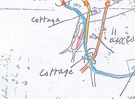
01
Unknown source, original held by Geoff Moy
 |
02
A=Chillwater, B=Netherwood Lane, C=Drax Turnpike 1842
From "Lake Farm Map - 1848", original held by Geoff Moy
 |
03
From "Discovered by H.P.Smith in 1943",, original held by Geoff Moy
 |
04
Unknown source, original held by Geoff Moy
 |
|
These articles, written by Geoff Moy, gives his opinion about which
Parish Lake Mill lies in.
FOR A THOUSAND YEARS LAKE MILL WAS PART OF CANFORD!
Lake, indicated on Saxton's map of Dorset of 1573, was a hamlet in
Great Canford with cottages, an Alehouse (The Castle) and a mill, all
had disappeared by the second half of the 19th century except Lake
Farmhouse.
Great Canford, later just called Canford, was the parish and manor formed
by the amalgamation of two Saxon villes Canford and Kinson both recorded
in the Domesday Survey of 1068. Canford dominated the Hundred of Cogdean
which included Corfe Mullen. Canford covered 85 sq. km., but the Canford
Estate extended in part over a kilometre into Corfe Mullen giving Canford
Manor control over Lake millstream. When my grandfather, the tenant, in
1921 bought Lake Farm from Canford Estate, the Estate included the site of
Lake mill.
Feasibly one of two Saxon mills listed in Canford's entry in the Domesday
Survey. Canford's Population Survey of 1851 listed the mill as occupied.
An unnamed building on the site of Lake Mill is shown on a railway drawing
circa 1857.
Was Lake a transport hub? The Romans came to the shores of Canford at Hamworthy and travelled on a road through Lake to Badbury Rings. With the rise of Canford's port at Poole in 13th century the principal crossing of the River Stour was at Canford Bridge, recorded in the mid 15th century when Canford was governed by the King's son licensing Poole as Dorset's principal port.
Roads going West from Wimborne passed through Lake. John Ogilby's strip
map of 1675 indicated a route to Lakeford South from Canford Bridge.
Julian's Bridge (1653) gave a more direct route from Wimborne to Lake.
With the introduction of turnpikes more wheeled traffic demanded wider
bridges. Julian's Bridge was widened in 1843 when Draxes turnpike crossed
Lake.
Corfe Mullen by comparison a small parish of 12 sq. km. was listed in the
Domesday Survey as a Saxon Ville with a watermill but as a result of the
Norman Conquest lost status. The land was divided into several Manors and
the parish was controlled by Sturminster Marshall. The church administered
civil responsibilities such as poor law relief and roads.
Corfe Mullen was ignored in the reforms of the early 19th century including
the restructuring of the Cogdean Hundred. The parish was not re-established
until the more democratic reforms about the eighth decade of 19th century.
All but 20 sq. km. of Great Canford is controlled by Poole Borough who first
had some independence from Canford in 1248. Confusion occurs as Netherwood
and part of Lake were transferred to Cowgrove in 1932 confusing those who
do not have local grandparents. This confusion is also generated by the
fact that Canford is partly served by the post towns of Wimborne and
Bournemouth.
Geoffrey Moy
020 May 2014
|
LAKE CANFORD MAGNA AND ITS WATER MILL
My family Frampton to Austin to Moy as tenants and later owners of Lake
Farm for over 150 years controlled the site of Lake Mill for some time.
John Hutchins in his history 'The History & Antiques of the County of
Dorset', first published 1774 vol.III referring to Great Canford and last
published in 1863, places Lake correctly in Great Canford as a small hamlet.
In addition to the mill a pub called the Castle (see Andrew Hawkes book
'A Pint of Good Ale - Poole's Inns, Taverns & Breweries', 2009) and several
cottages.
Early maps of Dorset, showing Lake, indicate its past importance , maybe a
ford:-
- Saxon 16 century Dorset map indicates Lake and a bridge at Canford.
- Speed
In order to understand the ownership of Lake Mill, one must appreciate that
it was part of a vast and prosperous estate. In Saxon times the manors of
Canford and Kinson were controlled by a single person under the territorial
name of Great Canford.
It was subdivided into five areas - Canford Magna, Longfleet, Hamworthy,
Kinson and Parkstone. In the 13 century Poole obtained some independence
creating a sixth division. With the creation of more democracy, in 1842
Poole Borough absorbed Hamworthy, Longfleet and Parkstone, and in 1888
by the creation of County Council the remainder of Great Canford was
superceded by Kinson and Canford Magna.
Lake then became part of Canford Magna which was absorbed into Poole
Borough in 1932 but the area north of the Dorset Central Railway Line was
transferred to the administration of Pamphill parish but this did not alter
the ownership of land.
The powerful Canford Estate extended beyond the feudal western boundary the
Chillwater stream into Corfe Mullen, the estate map of 1908 indicates that
the land to the south of the stream to Lake Mill is in the Estate's
ownership. Tenants were required to keep ditches clear. You did what you
were told, my ancestor Charles Austin, tenant of Lake Farm, was dressed
down for neglecting the stream discharging from the Mill.
The following maps and information should be considered:-
- Pre 1066 - Cogdean Hundred.
- 1087 - Domesday Survey - Canford - 2 mills.
- 1575 - Saxton's Map of Dorset showing Lake.
- 1606 - William Gillingham tenant Lake Mill - John Palmer.
- 1636 - Julian's Bridge.
- 17-19 C. - Moxhams Mead.
- 1750 - Establishment of turnpikes to Poole - Poole to Blandford via Corfe Mullen.
- 18 C. - Road Map showing branch to Lake Ford.
- 1808 - Great Canford - Poole Museum History Centre.
- 1811 - one inch OS map showing Netherwood Lane.
- 1841 - Canford Census includes Lake Mill - John Palmer.
- 1842 - Draxes turnpike.
- 1848 - Map attached to Tenancy Lake Farm, Great Canford - Poole Museum
History Centre.
- 186? - Barnes of Poole's proposals at Lake Gates for Dorset Central
Railway.
- 1908 - Canford Estate plan - part at Lake - Poole Museum History Centre
- 1922 - Plan of sale of Lake Farm to Charles Austin - G Moy.
- 1943 - Roman Road at Lake Mill - H.P. Smith, History of Poole, Vol. I.
Although the western boundary of Canford is the Chillwater stream (also
mill race), the boundary is extended westwards to encircle the Mill.
Lake Mill Canford, a Saxon Mill, was one of the two mentioned for Canford
in the Domesday Survey of 1087.
Research is needed to establish when the mill closed - possible reasons:-
- Establishment of turnpikes.
- Cornmarket in Poole - export.
- Inclosure Acts destroyed small Cottagers etc.
- Was weir lost and not replaced?
The millstone still exists, it was in a garden on Lake Farm and transferred
without authority to a site in Wimborne Minster.
Memories of the site include bathing, ice skating and a bridge across the
Chillwater.
Great Canford had poor soils as opposed to estates north of the Stour.
Netherwood was used for hay necessities for Canford's horses.
G R P Moy
Revised 11 April 2014
|
Email to Corfe Mullen parish council 09oct2013
Can I draw your attention to the Mill after which Corfe Mullen is named?
The name "Corfe" in Domesday 1086 had changed to "Corfe Molyn"
by 1176. At that time the well preserved Mill now known as
"Mullens Mill" (next to the Coventry Arms) did not exist. "Mullens"
is at the most medieval, and has a date inscribed "AC 1714".
However, there was a water mill known as Lake Mill further East,
probably dating back to Saxon times and located right on the parish
boundary. The boundary, drawn up in Saxon times, follows the
Stour and the leat supplying water, then appears to loop round
the location of Lake Mill. Lake Mill was also next to the old road
linking Wimborne and Dorchester, necessary to carry away
mill produce.
Domesday states there was only one mill in Corfe (valued at
20 shillings). It seems certain this was Lake mill, which gave its
name to Corfe Mullen. Unhappily, Lake Mill has now
disappeared and the site is covered by heavy vegetation.
However, many clues to the existence of Lake Mill can still be
seen, such as Weir Lane, a sunken weir, the leat taking
water from river to the mill, more old leats and a probable
mill pond. The approach leat, once filled in, has now been
renovated by me so that it flows well in winter (it is on my land).
Would it not be an object of civic pride for Corfe Mullen if some
remnants of the lost Lake Mill could be uncovered? A "Time Team"
approach would be necessary. I already have the permission of
the landowner to investigate. I have compiled a webpage on the
Internet giving as much as I can discover about Lake Mill
|
Photoed, written, formatted, hyperlinked, hand-coded,
and copyright © 2012,
. All Rights Reserved.
|