Updated 12 Feb 2009
|
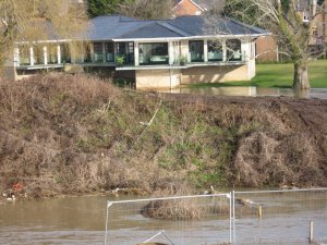
Flooding at Bear Mead 10 Feb 2009
|
|
Flooding at Bear Mead 10 Feb 2009.
|
A description of the high flood on 10 Feb 2009 at Bear Mead.
|
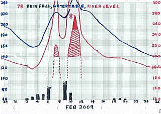
Three days of heavy snow, which was melting caused the
water table to rise to 220. Three days later, 39 mms
of rain in 24 hours caused Bear Mead to flood 24 hours later.
Peak flood was R=376, a height not seen since 2005 (Flood-1). |
29 Jan - 26 Feb 2009
Heavy snow melting
FLOOD-8
|
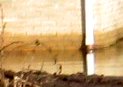
An interesting way of discovering that the peak of the Flood was
R=376.
In 2008 a new house was built close to Canford Bridge. At R=355
and 0957 on 11 Feb 09, a distant photo of the house was taken
from the South bridge approaches. R=355 was measured from the
scale at Eyebridge 27 minutes earlier. Enlargement of the photo
revealed that the water had just reached a wall of the house, and
since the last meaurement at 0015 the same day had been higher.
The "wet mark" on the bricks appeared to be 3 brick courses higher
than R=355. Assuming each brick course was 7cms high, this indicated
a maximum water height of R=355+(3x7)=376. This is unusually high,
and would account for the 90% Floodplain coverage observed. The high
point may have occurred about 0500 hours.
|
Telephoto of house built 2008 close to Canford Bridge.
 |
Enlargement showing flood level, brick courses and wet mark.
 |
Compiled, formatted, hyperlinked, encoded,
and copyright © 2005, John Palmer,
 All Rights Reserved. All Rights Reserved.
|