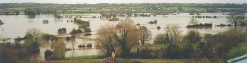
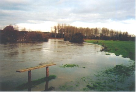
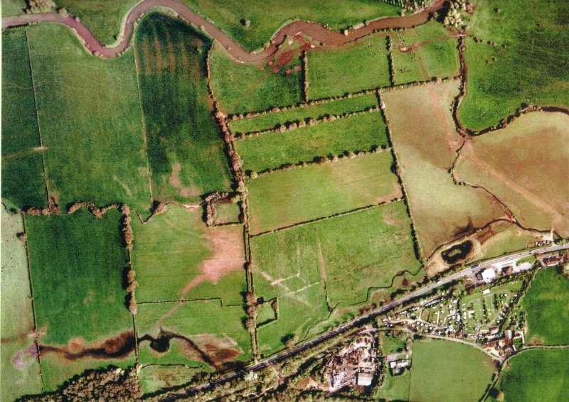
Looking South from Little Pamphill Green(OS Ref:ST995003) across the flooded
Stour and Eye Mead towards Corfe Mullen heights on the horizon.
Eye Bridge is near the centre foreground, a wooden footbridge crossing
the Stour channel.
The floodplain here is 1,000 metres wide, and is flooded from Cowgrove Road
to the A31 to a depth averaging 40 cms.
The Stour rose 2.56 metres in 24 hours.
A three-week drought ended 2 days before this photo was taken.
The cause was a 958 millibar depression dropping heavy rain over the
Dorset Stour catchment area stretching 40 miles upstream.
Picture taken 3 Dec 05 about 1530 hours. 36 hours later, the
flooding had mostly disappeared.
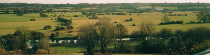
 The River Stour at normal height.
Picture taken 5 Mar 06
The River Stour at normal height.
Picture taken 5 Mar 06
|
Taken 14 Apr 2004, height 145 cms.
|
Taken 4 Dec 2005, height 355 cms (26 hours earlier it had been 30 cms higher)
|
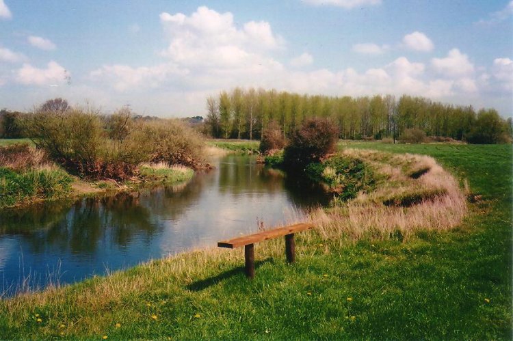
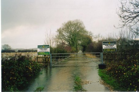
Approach bridleway to Bear Mead 15 Nov 2002.
This was the last similar flood.
The gate is 500 metres from the river.
Enlargement of Flood peak
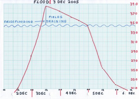
December levels
|
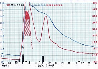
- On Friday 2 Dec 2005, a depression of remarkably low pressure
passed over the South coast of England. At 1510 hours a pressure
of 958.1 mB was measured by the Author at 70 metres above sea level.
- This low pressure was the direct cause of very strong winds
in the area, and intense rain from fronts attached to the depression.
- The author measured 32 mm of rain in 24 hours, and perhaps even more
fell onto all the large
catchment area of the Dorset Stour on 1/2 Dec 2005.
- Previous to this rain, there had been a 19-day drought over the catchment
area, and the river level had fallen to 129, as low as any seen in the
winter wet period since the author's records began.
- In 24 hours, the Dorset Stour at Bear Mead rose 256 cms, flooding the
1,000 metre wide flood plain to an average depth of about 40 cms.
The peak of the Flood was about 1200 hours on 3 Dec 2005. The river
then dropped to 345 in 33 hours linearly while draining the fields.
Flooding ceased at about 2300 hours on 4 Dec. The river then continued
falling exponentially back to its normal level.
See the graphs at left.
- Meanwhile the watertable level rose to the surface, and stayed there
even when the river sank back to a low level again. The high watertable
caused a saturated surface, small pools of surface water, and great
danger of renewed flooding on arrival of more heavy rain because of
run-off.
- Flooding occurs earlier higher up the Stour valley.
News of flooding at
Sturminster Newton (10-17 hours earlier) or
Blandford Forum (6-9 hours earlier)
should give the alert farmer time to move his sheep or cattle off
Bear Mead (1 mile upstream from Wimborne Minster) to higher ground.
A contact
R
at Marnhull (18 hours earlier) has sent very useful
warnings.
- The author's fields on the South bank of the Stour were flooded to an
average depth of 40 cms in about 4 hours. Water arrived from two
directions, from the North (from the river) and from the West (from
upstream fields flooded earlier). This caused a current to the South
East, carrying loose flotsam. After the flood, the lay of pasture
grass confirmed this direction.
- The author did not see the onset of the Flood. However clues in the
form of gravel shifted into wells and ditches, and hearsay evidence of
farm workers who saw similar floods in the past, suggest the following.
A low but dramatic "tidal wave", perhaps 20 cms high, arrived from
neighbouring fields to the West. Ponds and ditches were rapidly filled
by a "waterfall" of drop some 100 cms, strong enough to move gravel laid
earlier. In a few minutes, all water levels were the same.
- Flotsam included dead grass, branches, planks, loose fence posts,
buckets, straw bails, watering cans etc.
The flotsam moved South East until halted by hedges, deerfences, small
trees and the like.
Grass caught in the small plantation trees gave a good indication of
the maximum flood depth across a field, varying from 20-60 cms
Bales of hay stored by farmers on the flood plain became saturated.
- Wildlife not able to escape was drowned. Rabbits forced onto a main road
by flooded fields on each side were killed by traffic. Voles and mice
not able to escape upwards died. Local farmers had to move cattle and sheep.
Fortunately the flood occured in late morning. Had it happened at night,
many more animals might have died. Birds escaped drowning, but lost access
to their feeding areas for 60 hours. Deer tried to move to high ground,
forcing them towards the main road.
- Although the river fell rapidly after 36 hours, the watertable
remained at or close to the surface causing mud and pools of lying water.
The watertable was about 100 cms above the river, causing rapid runoff
at the next rainfall and making another flood more likely.
Time between rainstorms is needed to allow the watertable to drain into
the river until it is only 10 cms above the river height, which is average
for the winter wet season.
- The high watertable protects the pasture grass from the effects of frost,
allowing early and lush regrowth and two good cuts of grass in the year.
- 48 hours after the peak of the flood, the fields were walkable in
Wellingtons, and some repair and maintenance work could be done. From a
distance, the most of the flooding had disappeared.
- A neighbouring farmer had built a "haystack" of round bales in early
autumn, about 2.5 metres high, and covered them with tarpaulin. Although
the flood waters only rose some 20 cms above ground level, the lowest bales
were soaked, and much of the rest soaked by capilliary action in the
following two weeks. Evidence of fox was found at higher levels on the stack
where the animal had taken refuge under the tarpaulin.
|
|
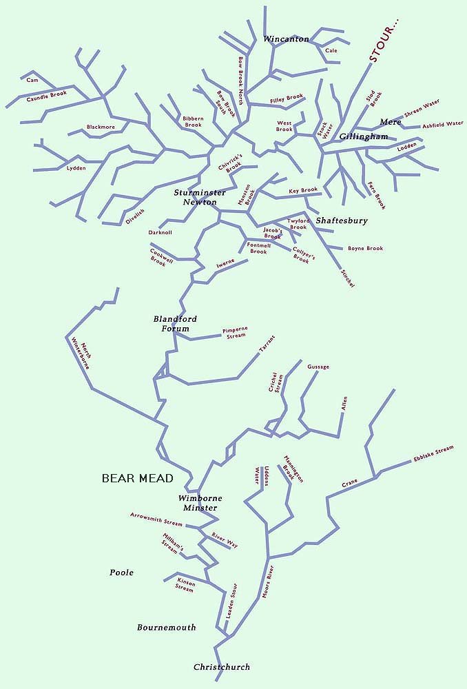
The Stour rises at St Peter's Pump in Stourhead Gardens. From Stourhead,
the river flows South to Gillingham where it is joined by the Shreen and
Lodden. Around Gillingham, the landform varies from expansive open
landscapes, to deep enclosed valleys running off the North Dorset
Limestone Ridge and onto clay. Further west and south, the Blackmore Vale
is broad and gently undulating, and is drained by the Stour and a dense
network of tributaries. This is a domestic farmed landscape of pastures,
scattered villages, hedgerows and small woodlands forming an irregular
patchwork.
Flowing South towards Sturminster Newton, the Stour is joined by several
clay-influenced tributaries including the Bow, Filley and Caundle Brooks,
the Cam, the Lydden and Divelish. The nature of the geology gives rise to
a dense drainage network, which is particularly responsive to rainfall.
Below Sturminster Newton, the Stour flows towards Blandford Forum through
a narrower valley with chalk hills either side. The landuse is mainly
arable on the gentle slopes towards the edge of the floodplain and pasture
on the flat valley floor. Settlements and roads tend to be concentrated on
the valley floor or lower slopes of the chalk escarpment. Tributaries here
are fewer in number, and include the Iwerne, Allen, Gussage, Tarrant, North
Winterborne and the Pimperne Stream.
At Wimborne Minster, the Stour flows over the geological boundary onto the
Tertiary deposits (mainly sands and gravels) and on towards Bournemouth
across a landscape of typically large open fields. These are predominatly
pature and arable whilst the settlements cluster along the outer margins
of the valley floor. At Wimborne the Stour is joined by the River Allen,
which flows over chalk for almost all of its length. This valley is
dominated by arable agriculture, with water meadows on either side of the
river and frquent copses of riverside trees.
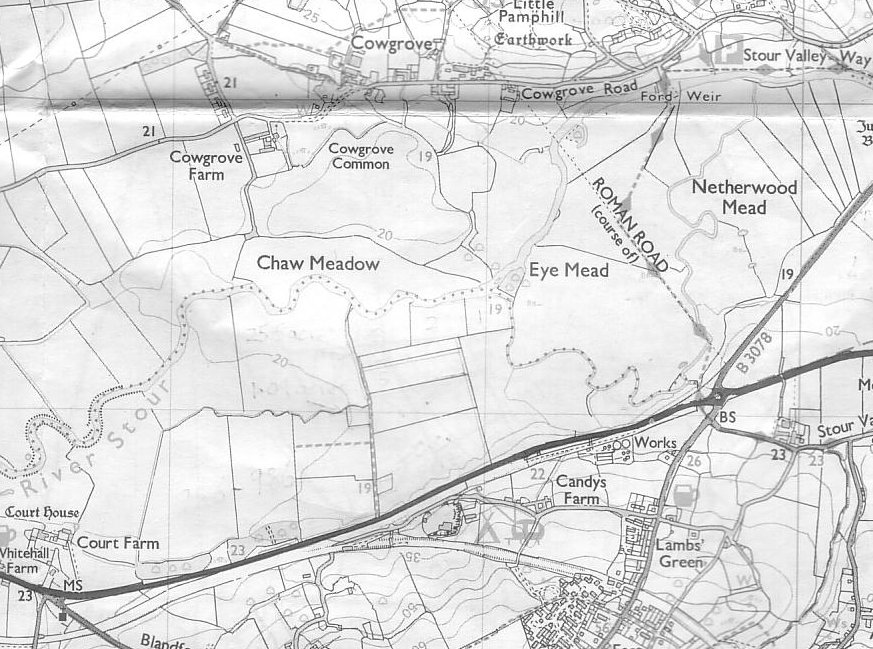
BEAR MEAD is marked on the map, near Wimborne.
The Crane rises on the chalk, but after it flows onto the Tertiary deposits
it becomes known as the Moors River. It is joined by the Uddens Water at
Ferndown, and joins the Stour at Hurn. It flows through a landscape of low
rolling hills, through an irregular and enclosed patchwork of pasture,
woodland including coniferous plantations, hedgerows and heathland.
In Bournemouth, the watercourses are an important part of the townscape,
as narrow, wooded corridors. The coastal fringe is heavily populated with
the main centres of Bournemouth, Poole and Christchurch. The River Stour
comes to an end when it flows into Christchurch Harbour.
|
|

 The same area on a modern map