Updated 31 Dec 2009
|
The Eye Mead Project
|
|
|
The Eye Mead Project
|
Author:
|
The PROJECT
- Restore an arm of the River Stour in Dorset, England (artificially blocked about 1700).
- Fit a pipe with valve over a distance of 40 yards in land owned by the author.
- Refresh with flowing water 1.75 miles of stagnant meander across the river floodplain.
- Benefit wildlife, tourism, farm animals and reduce flooding downstream.
|
The PLACE
- Eye Mead is 119 acres of meadow and pasture on the floodplain of the River Stour in Dorset, England, about 1 mile West of the small town of
Wimborne Minster.
- Eye Mead is surrounded by two arms of the river, making an island of meadow (hence the name, see Ref.2).
- About 1960 the North arm of the Stour was "canalised" (straightened and deepened). At the same time the start of the Southern arm was blocked over 40 yards where the two branches diverge. See Ref.1.
- In 1813 the Southern Arm was called "Lake Mill Stream", and carried enough flowing water to drive "Lake Mill" which was close to the present roundabout on the A31 trunk road.
- Over the last 40 years the Southern Arm has held stagnant water and become overgrown with vegetation. If nothing is done it will slowly disappear as the stream bed fills with silt, to become just a two-mile long depression in the grass.
More....
|
The PLAN
- The author discovered the situation when his family bought land in 2002 which contains the 40 yards of blockage of the old Lake Mill Stream.
- The author proposes to dig a ditch through the 40 yards of blockage, enabling the present river to connect with the old Lake Mill Stream.
- A pipe will then be laid in the ditch, with a Stop valve to control the flow of water.
- The ditch will then be filled in again, so that water will only flow into the Mill Stream when the valve is opened.
- In times of drought, the main river will be below the level of the Mill Stream, no water will flow, and the Stream will be as it is today.
- In times of flood (occasionally in the winter), water will flow over the present bank and across the floodplain which stretches 500 yards each side. The Mill Stream will be flooded just as it is today.
- During normal River levels, water will be directed into the Mill Stream, encouraging the Stream to regain its natural function.
- Explore the possibility of selling the land containing the pipe to the National Trust to pay for the Project and keep control of the valve in NT hands.
- Read a short Magazine Article about the Project.
More....
|
The PROBLEMS
- The usual problems arise, permission, money and consequences.
- The author has yet to discover just when the Stream blockage was created, by whom and for what reason. Almost certainly the one-time River Authority was involved, now called the Environmental Agency.
- Permission would have to be obtained from those who own land on each bank of the 1.75 mile Mill stream. The landowners have to be identified first. The major landowner is the National Trust, locally based at Kingston Lacy.
- Permission has to be obtained from bodies looking after the interests of the Environment and the Trunk Road (A31) nearby.
- The consequences of refreshing the Mill Stream have to be studied and approved by the experts at the Environmental Agency
- A sewage outfall exists a few yards upstream of the proposed pipeline to the Millstream.
- Finally the two greatest questions have to be decided: who pays, and how much. Plans must be drawn up, quotes obtained and grants requested.
- Time has to be found for all these matters. At present the author's time is mostly spent building and maintaining one of the largest handcoded websites on the Internet (see
Wirksworth website)
More....
|
The PAY-OFF
- The Mill stream will act as extra storage during flash floods, reducing flooding down stream.
- The full Mill stream will act like a 1.75 mile long lake,
attracting wading birds.
- The Mill stream will provide drinking water for cattle and sheep on its banks.
- A "soggy landscape" retains water in summer and absorbs
the winter rainfall, releasing it gradually into the lower stretches of the river over many months - preventing the sudden floods we have now.
- Straightened, cananalised rivers waste precious
summer rain and rush winter flood water into towns downstream.
- Encourage alder, oak and willow to grow along the 3.5 miles of stream bank
- Provide a more interesting waterside walk for the National Trust lands.
- Help local wildlife by restoring the Dorset Stour to its wild and natural state.
More....
|
Responses by Organizations and Landowners
|
|
Maps, Aerial Photos and more info.
|
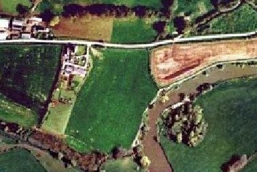
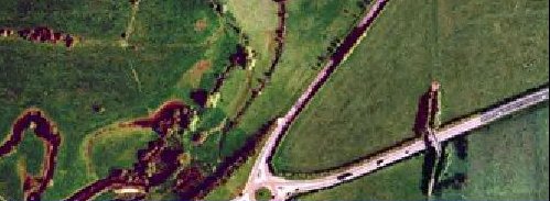
Showing the 119 acre "island of meadows" enclosed by the two arms of the River Stour and called "Eye Mead",
and the islands in the river which today are part of the river bank.
|
|

Showing Eye Mead today, the course of the Roman Road, the new A31 and Lake Gates roundabout, Eye Bridge (a wooden footbridge), the nearby Ford and Weir, and Cowgrove Road (a lovely hedge-lined minor road joining Wimborne Minster and Blandford Forum)
|
|
|
|
See how the Ox-bow stands out....
|
|
3a. 1811 OS map
|
|
Points of Interest
- This map was first drawn 1811, but later additions (such as the railway) were added up to 1870.
- The Southern branch of Stour at Eye Mead looks as wide as the Northern branch.
- Has the first mention of a Bridge at Eye.
- A curious "road" (going nowhere) at the side of the straight road to Wimborne, is this the remains of the "old road"?
- There is no definite sign of Lake Mill.
- There is a road reaching the Stour close to the point of divergence of Lake Mill Stream
|
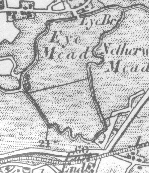
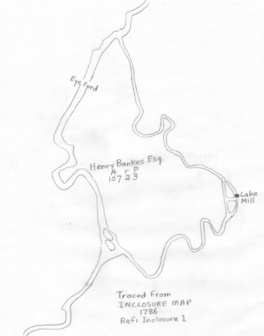
4. EYE MEAD from Corfe Mullen Inclosure Map 1813
|
|
There is today no trace of the
Lake Mill,
but on this 1813 map it is shown as being driven by the
Lake Mill Stream,
which must have flowed strongly in those days.
The road to Wimborne is not the present road, but traces of the old road can still be seen in the fields. The Parish boundary follows the Mill Stream, showing its importance, but as this map is a Parish map, details from "across the border" are missing.
|
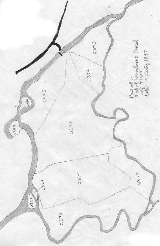
5. EYE MEAD from a Map of Wimborne Parish 14 July 1847
|
Points of Interest:
- Lake Mill Stream is about 1.75 miles in length, enclosing an area of 119 acres of meadow and pasture on the Stour floodplain.
- The numbers are reference numbers to fields awarded at the time of the Inclosure Act 1813.
- 2380-2381-2383-2384 were islands in 1847, today they have "grafted" onto the nearest bank, possibly part of the canalisation exercise on the River.
- These "old islands" still retain close-growing 200-year mature trees, including white willows and alders, that have nearly vanished from the mainland.
- The peninsula on field 2373 where the two
Stours re-met, and the oxbow, show the water in the minor loop once had a sturdy flow.
- The peninsula where the Mill Stream rejoins the Stour has today silted up, but a direct channel now exists.
- Lake Mill was located near the little island and field 2377, at OS reference 9955-9912 where there is now a low
earth platform.
- A spur down to the river from Cowgrove Road existed then, as well as a ford or possibly a bridge where the present wooden footbridge is.
- Rodney Legg says "Traditional agriculture used to encourage the flooding [of these meadows] in winter as this prevented the ground freezing and brought on an early crop of
grass."
|
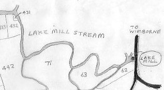
5a. EYE MEAD from an Inclosure map of 1786
|
Points of Interest:
Text from the same document:
"...One plot or parcel of land lying and being in Eye meadow Close and Leaze and containing 107 acres 2 roods and 3 perches. Bounded on or towards the East side by a back brook or rivulet running from Lake Mill into the River Stour - on or towards the South and South west by the Stream or brook running to the said Lake Mill - and on every other part by the River Stour and two Hooks belonging to the said Henry Bankes called Trendles Holes which were not subject to common Right".
- There is an accurate area for Eye Mead (in Acres, roods and perches).
- "Eye Ford" is shown near where Eye Bridge is today.
- A well-developed ox-bow is shown on the main river (which today has "collapsed" to an area of trees on the North bank).
- The position of Lake Mill is accurately shown, beside two islands in Lake Mill Stream.
- The ox-bow in the Mill Stream has not developed any further since 1786.
- The start of the Mill Stream (next to the two islands) is shown as being quite wide.
- Eye Mead (owned by Henry Bankes in 1786) is one of the few parts of the Bankes' estate to the South of the river, and was left to the National Trust in 1983.
|
5c. EYE MEAD from an O.S. map (1903 Revision)
|
5b. EYE MEAD from an O.S. map (3rd Revision 1913)
|
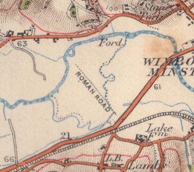
6. EYE MEAD from an OS map dated 1997
|
Points of Interest:
- A public carpark is shown next to the bridge. This car park is the only practical one for exploration of the area.
- A Ford is shown between the footbridge and the weir. This is now too deep for vehicles because of the weir.
- Downstream, the Mill stream is shown as not quite connecting with the Stour.
- No contours cross Eye Mead - it is a very flat floodplain.
- The public footpath follows the course of the Roman road for some way.
- A height of 19 metres above sealevel is shown for the start of the Mill stream
- The stream is also shown connecting directly to the river (which it has not done for many years!).
- The Parish boundary is shown following Lake Mill stream from the main Stour to the A31 Roundabout.
- Location of the Roman fortress is not shown, but was 30 acres centred near the roundabout (at the letter B of B3078).
- Location of Lake Mill is not shown.
|
6a. Movement of Islands
Islands 2383 and 2384 (see 1847 map) have "crossed the river". In 1786 "2383" was within an oxbow and part of land on the East of the river. In 1847 it was an island after the oxbow was cut through at its neck, and in 1997 it is part of land on the West of the river. Island 2384 has crossed from West to east in the same period.
Meanwhile, Islands 2380 and 2381 have merged and moved to "weld" with the East bank. During this period of great change on the main Stour, the oxbow on the Mill Stream has remained "frozen", probably because of low flow, pointing to an early blockage.
Most islands are easily recognizeable by still being covered with mature trees.
|
1786
|
1847
|
1997
|
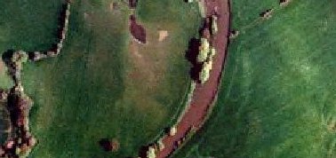
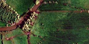
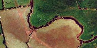
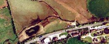
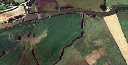
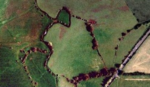
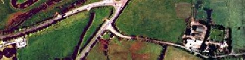
7. EYE MEAD from a mosaic of Aerial photos taken about 2001.
|
For those who know the area: The A31 with an Esso petrol station...
|
.... and shop, a Little Chef Restaurant (good place to meet and eat), a Caravan Sale area, a Sewage Treatment Works, and the original Lake Farm.
Different farming methods produce different colour grass in the meadows according to the time of year, often showing ownership.
|
Points of Interest:
- The weir with its trail of white water can be seen on the main river at the top, with the wooden footbridge nearby.
- The round wood and the long wood on the river bank used to be islands in the river! (see the 1847 map).
- The area inside the two arms of the Stour is mostly owned by the National Trust (Kingston Lacy Estate). This
"Island of Meadows" gave rise to the modern name "Eye Mead".
- The lovely Ox-Bow is the most instantly noticeable feature of the old Mill Stream seen from the air.
- A Roman Road can just be seen which once forded the river by the side of Round Wood, coming from the Roman Fortress
- Lake Gates Roman Fortress was centred just NE of the centre of the roundabout and built by the 2nd Augustan Legion of veterans commanded by Vespasian (later Emperor). The Legion used the fortress as a springboard to attack a tribe called Durotriges in South West England, were succesful, and changed English history, language, and culture for ever.
- The A31 trunk road and Lake Gates roundabout are clearly shown.
|
8. Wimborne Minster, Dorset, England
|
Points of Interest:
- EYE MEAD lies about 1 mile West of Wimborne, centred near the letter "R" of "Roman Fort" in the centre of this map.
The Ox-bow ia a noticeable feature of the Mill stream.
- Wimborne is a small town, but just off this map to the right lies the large built-up area of Poole-Ferndown-Bournemouth, containing over half a million people.
- An area to the North West of Eye Mead is owned by the National Trust, and contains Kingston Lacy, a noble house bequeathed to the Trust by the Banks Family. It is a treasure house of precious objects, and a great tourist attraction.
- The River Allen flows through Wimborne and joins the Stour just to the South of the town.
|
REF. 1
|
GOOD independently suggests that the Stour has changed its bed (though he dates the change to around 1700), and that there was a ford at Lake.
He points out that the "Lake Mill Stream" is still a parish and local government boundary, but was unaware of the Roman fortress at Lake, controlling the direction of the Roman roads.
From: "The Old Roads of Dorset" by Ronald Good, Page 42: (first published 1940)
"....On the West side of Wimborne the story is interesting but complicated. Historically it begins with the Roman Road from Badbury to Hamworthy which ran South-East from near Cowgrove to a point a little West of Lake Farm, where a minor loop of the river comes close to the present main road [A31]. Next, Ogilby [1675], in his description of the road from Wimborne to Poole (see p 56) mentions and depicts a road running Westward from near Canford to "Lakeford". Again, South of Cowgrove, and approached by Weir Lane, there is an old ford just West of, that is to say, above, the spot at which the river loop just referred to leaves the present main stream. Finally, South of Pamphill there is a broad, hedged, approach to the river where a ford is marked on 6" OS and where, until the Second World War there was a substantial iron foot-bridge, Eye Bridge, though there does not seem to be any sign of a road running to it from the South side. The clue to the explanation of all this is that although Lake is now half a mile or so from the river both the Roman road and Ogilby suggest strongly that there was a ford at Lake and if so this can only have been on what is now the subsidiary loop of the river. It therefore looks very much as if between the time of Ogilby, 1675, and Taylor's map, 1765 (see p 53), which shows the river as it is now, the Stour changed its course here, being either naturally or deliberately diverted along its present more direct line from just East of Cowgrove ford to a point South of Stone Park leaving the former, much longer, bed of the river to become gradually reduced by silting and filling. If this is indeed so then with the loss of Lake ford another crossing became necessary across the new river south of Pamphill, and this is provided at Eye Bridge. Two more points should be noticed. The Roman Road is shown on maps as changing its course hereabouts, but this is not wholly convincing, and if the Southern leg of the road is produced a little further north beyond its apparant termination it comes very close to the presumed site of Lake ford. Second, our idea that the river has changed is strongly supported, and some may think even proved, by the fact that the old river loop was until 1933, and is still partly, a local government and parish boundary like the main bed West and East of it....."
|
REF. 2
|
EYE MEAD: the name is first mentioned in 1253 and means "An Island Meadow" because it is encircled by the River Stour.
From: "Place-names of Dorset" by A D Mills, Part 2, page 166, Parish of Pamphill (before 1894 was in parish of Wimborne Minster).
EYE BRIDGE & MEAD (SY 995995), (6 acres in) Eye 1253 Drew, ? Hya n.d. (1372) ChrP, pastur' de Ey, Ymede1468 MinAcct, Ey mede, Eylezen 1547 DLMB, Eye (Meade, -Meadow, -Leasinge), Ile leises, -Meadowe 1591 ib, Eye Meade 1598 DLComm, from eg, WSax i(e)g 'an island', replaced in some 16th cent.forms by ME ile 'an island', with maed 'meadow', laes 'meadowland' (with ME pl. -en), cf.Eye He, Mx, etc (DEPN), v. Weir Lane infra. Eye Mead is encircled by R. Stour and its trubuteries.
Drew=Col C D Drew's manorial index in Dorset County Museum; ChrP=Cartulary of Christchurch Priory in British Museum (Cotton Tib. D VI); MinAcct=Minister's Accounts in PRO; DLMB=Duchy of Lancasters Miscellaneous Books in PRO; DLComm=Duchy of Lancasters Special Commissions in PRO; WSax=West Saxon; ME=Middle English.
|
REF. 3
|
LAKE FARM: mentioned 1575. Lake Mill was called Gillingham's Mill.
From: "Place-names of Dorset" by A D Mills, Part 2, page 3, Parish of Canford Magna.
LAKE FARM (SZ999989), La(c)ke 1565 Comm, Lake 1575 Saxton, e17 BRA et passim, no doubt the home of John atte Lake 1332 SR, cf John Lake 1374 MinAcct, Gillingham's Mill now Lake Mill, Lake Mill Stream, Over Lake 1822 EnclA, v. lacu 'a stream, a water-course', atte, uferra; the farm stands on a small tributary of River Stour called Chelwell Water 1822 EnclA.
Comm=Exchequer Special Commissions in PRO; BRA=Publications of the British Records Association; MinAcct=Minister's Accounts in PRO; EnclA=Unprinted Enclosure Awards in DRO
|
REF. 4
|
Bear Mead, Great Wood, Little Wood (local field names) all connected with wood
From: "Place-names of Dorset" by A D Mills, Part 2, page 18, Parish of Corfe Mullen.
BEAR MEAD (v. bearu 'wood' or baer 'woodland pasture').
GREAT WOOD (1742 (Corfe-)).
LITTLE WOOD (1742)
|
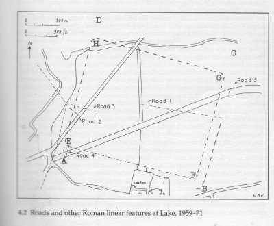
9. Location of Roman Fort at Lake
From:Dorset and the Second Legion by N H Field
|
Points of Interest:
- Lake 1 (ABCD) was established 45 AD, of 41 acres.
Lake 2 (EFGH) was established 55 AD, of 32 acres.
- Served as winter quarters for a battle group, and know as a Vexillation fortress
- The present day roundabout on the A31 is centred just west of "A".
- There may have been a natural ford here over the (then) main arm of the Stour. The area is likely to have been well wooded.
|
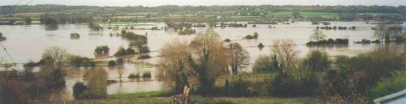
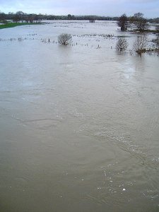
EYEMEAD in FLOOD.
Looking South from Little Pamphill Green(OS Ref:ST995003) across the flooded
Stour and Eye Mead towards Corfe Mullen heights on the horizon.
Eye Bridge is near the centre foreground, a wooden footbridge crossing
the Stour channel.
The floodplain here is 1,000 metres wide, and is flooded from Cowgrove Road
to the A31 to a depth averaging 40 cms.
The Stour rose 2.56 metres in 24 hours.
A three-week drought ended 2 days before this photo was taken.
The cause was a 958 millibar depression dropping heavy rain over the
Dorset Stour catchment area stretching 40 miles upstream.
Picture taken 3 Dec 05 about 1530 hours. 36 hours later, the
flooding had mostly disappeared.
|
|
|
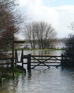
Eye Mead sometimes floods after prolongued rain in the winter.
The flood plain is 1200 yards wide at this point.
The level of the River, and of the Water Table at Bear Mead nearby, are given at Flooding on the Dorset Stour.
These pictures, taken in 2000, show what happens when the floodplain floods. They were taken from Eye Bridge. The floods usually arrive quickly but also depart quickly, leaving the ground very soggy indeed. The depth of the water-table is a good measure of the "sogginess".
|
|
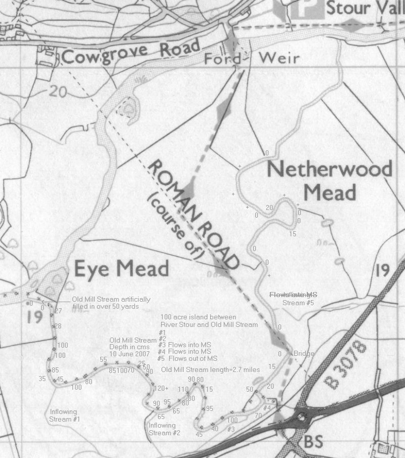
The depth of the Old Mill Stream measured on 10 June 2007.
The OMS was silted up from the NT bridge to the Stour East of Eyebridge.
Small inflowing streams from Corfe Mullen Heights appear to keep some
water in the OMS upstream of the NT bridge, although it is stagnant. The main exit now seems to be Stream #5, passing under Julian's Road and linking with the Stour to the West of Julian's Bridge.
In places trees or shrubs overhanging the OMS limit light reaching the water and prevent reeds growing, so detering silting.
It appears that flowing water along the complete OMS length is now
not possible, but linking with the upstream Stour might exit along
stream #5, and so fill about half the length.
|
Compiled, formatted, hyperlinked, encoded,
and copyright © 2003,
John Palmer
All Rights Reserved.
|