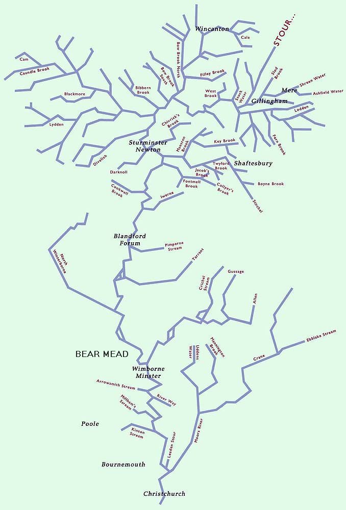
The Stour rises at St Peter's Pump in Stourhead Gardens. From Stourhead,
the river flows South to Gillingham where it is joined by the Shreen and
Lodden. Around Gillingham, the landform varies from expansive open
landscapes, to deep enclosed valleys running off the North Dorset
Limestone Ridge and onto clay. Further west and south, the Blackmore Vale
is broad and gently undulating, and is drained by the Stour and a dense
network of tributaries. This is a domestic farmed landscape of pastures,
scattered villages, hedgerows and small woodlands forming an irregular
patchwork.
Flowing South towards Sturminster Newton, the Stour is joined by several
clay-influenced tributaries including the Bow, Filley and Caundle Brooks,
the Cam, the Lydden and Divelish. The nature of the geology gives rise to
a dense drainage network, which is particularly responsive to rainfall.
Below Sturminster Newton, the Stour flows towards Blandford Forum through
a narrower valley with chalk hills either side. The landuse is mainly
arable on the gentle slopes towards the edge of the floodplain and pasture
on the flat valley floor. Settlements and roads tend to be concentrated on
the valley floor or lower slopes of the chalk escarpment. Tributaries here
are fewer in number, and include the Iwerne, Allen, Gussage, Tarrant, North
Winterborne and the Pimperne Stream.
At Wimborne Minster, the Stour flows over the geological boundary onto the
Tertiary deposits (mainly sands and gravels) and on towards Bournemouth
across a landscape of typically large open fields. These are predominatly
pature and arable whilst the settlements cluster along the outer margins
of the valley floor. At Wimborne the Stour is joined by the River Allen,
which flows over chalk for almost all of its length. This valley is
dominated by arable agriculture, with water meadows on either side of the
river and frquent copses of riverside trees.
BEAR MEAD is marked on the map, near Wimborne.
The Crane rises on the chalk, but after it flows onto the Tertiary deposits
it becomes known as the Moors River. It is joined by the Uddens Water at
Ferndown, and joins the Stour at Hurn. It flows through a landscape of low
rolling hills, through an irregular and enclosed patchwork of pasture,
woodland including coniferous plantations, hedgerows and heathland.
In Bournemouth, the watercourses are an important part of the townscape,
as narrow, wooded corridors. The coastal fringe is heavily populated with
the main centres of Bournemouth, Poole and Christchurch. The River Stour
comes to an end when it flows into Christchurch Harbour.
|
|
 All Rights Reserved.